Course details
- A level requirements: ABB
- UCAS code: F7F6
- Study mode: Full-time
- Length: 3 years
Return to top
Study Environmental Science at Liverpool and become part of the solution in tackling climate change and other environmental challenges. You’ll gain the skills necessary to understand how the most important aspects of planet Earth work, and how to apply that knowledge to make a difference.
To save the planet, we need to understand the planet. You will develop key knowledge and skills to help tackle the effects of climate change and ensure a sustainable environment for all.
You’ll graduate with a broad knowledge of environmental science, and a range of skills spanning problem solving, numeracy and coding, field work, data acquisition, and report writing and communication skills, all designed to equip you for a career helping maintain a sustainable environment on our planet.
You will be taught by research-active staff, at the forefront of their chosen fields, within small groups for a collaborative and conversational experience.
By the time you graduate, our extensive field training will have equipped you with the specific practical skills necessary for a career in Earth Sciences.
Please note that this course may be subject to change, and is pending formal validation.
A number of the School’s degree programmes involve laboratory and field work. Fieldwork is carried out in various locations, ranging from inner city to coastal and mountainous environments. We consider applications from prospective disabled students on the same basis as all other students, and reasonable adjustments will be considered to address barriers to access.
We’re proud to announce we’ve been awarded a Gold rating for educational excellence.
Discover what you'll learn, what you'll study, and how you'll be taught and assessed.
The module uses laboratory experiments to allow students to gain first-hand experience of some fundamental physical, biological and chemical processes underlying physical geography, aimed primarily at interactions between people and their physical environment. It is designed to provide a foundation for environmental modules in the second and third years. This module comprises multiple whole-day practical sessions, each designed to give students first-hand experience of a topic important in understanding our changing environment. Dedicated computer practicals are also run to provide training in use of EXCEL, MINITAB, and basic inferential statistics. Students get formal feedback in each assessed week (one poster per group). However, perhaps most valuable is the feedback obtained informally via discussions during the sessions.
This module provides a basic introduction to sedimentology and palaeontology. Students learn about the origin of sediment, sedimentary processes and structures and the ways in which sediments are converted into solid rock. The course outlines the importance of sedimentary rocks for hydrocarbons, water and as construction materials. Students learn how to describe and interpret sedimentary deposits.
The palaeontology component introduces students to the major fossil groups and to the ways in which organisms can be preserved as fossils. It covers the importance of fossils for the study of evolution, environmental change and earth history. Students learn how to describe fossils and how observations contribute to a broader understanding.
Students will be assessed by means of two practical tests and a theory examination.
This field module provides a basic training in field techniques and gives students practical experience working with a wide range of rock types and tectonic structures to solve geological problems. Students gain experience in recording field data and use their own data to interpret geological processes and environments. The module is assessed by means of an individual fieldwork portfolio and a group synthesis poster completed after the field class.
This module introduces a key subject within Earth Sciences, Structural Geology and Geological Mapping. In this module you will be introduced to geological structures from the micro to the mountain scale, and receive training in the geometrical techniques used to document and analyse them. You will also learn the basic principles of stress and strain which underpin a number of advanced Earth Science subjects and skills used in industry and research. Finally, the module will provide training in how to read and understand geological maps, and train your 3D visualisation skills by learning how to create geological cross-sections from maps, and how to stereographically plot 3D geological data. A combination of virtual lectures, practical skill development sessions, discussion sessions, and directed reading will help you navigate this important Earth Sciences topic. You will be assessed on the development of your practical skills through an end-of-semester open book practical exam, and you will write an individual research paper on a specific topic in structural geology.
This module introduces students to the key skills necessary to succeed on a University Earth Science course. It does this via a series of lectures, workshops and tutorials, together with a geology fieldwork day and attendance at departmental seminars and talks. The lectures, towards the start of the first semester, cover academic integrity, exam skills, employability and 2D/3D visualisation. Tailored workshops cover Geographical Information Systems (GIS), Word, Excel and programming skills. Small-group (typically 4 to 8 students) tutorials are run by academic staff and cover essay writing (including assessment), careers and employability. Academic tutors undertake personal development planning (careers and module selection advice) with each tutee.
This module will introduce and develop understanding of rock-forming minerals and critical raw materials in terms of their environments of formation, occurrence, and abundance. The module will focus on exploring the uses and societal significance of a range of Earth materials, especially those critical to sustainable and renewable energy resources and various societal infrastructure. The key practical skills of mineral description, identification and interpretation will be developed and applied throughout the module to equip students with appropriate skills for many later geoscience modules and for future employment.
This module provides an introduction to the Earth and aims to teach students about the structure and composition of the Earth, the Earth’s gravitational and magnetic fields, and dynamics within the deep Earth; the physics of Earth material and the geological time scale; and plate tectonics. The course is delivered through a combination of lectures and practicals. Students are assessed through a combination of coursework and a final exam.
This module will give students an understanding of the fundamental properties of elements and matter, either solid, liquid or gas, in the context of the environmental sciences. It will introduce the fundamentals of atomic structure, elements and molecules from simple inorganic to large organic ones and the bonding forces that hold them together. It will look at the basics of chemical reactions such as the processes of oxidation and reduction, the solubility of solids and gases in water and acid-base properties. Students will learn how to make quantitative predictions, for instance on the amount of products that will be produced based on balanced chemical reactions, and will see how basic chemistry can be used to explain many environmental properties. The module is taught through lectures, tutorial sessions and online formative quizzes with automated feedback. Assessment is through online tests and an open book final exam. This module is largely an introduction to chemistry and might therefore not be well suited for students who did A-level chemistry or equivalent.
The module uses a lecture and laboratory-based problem-solving approach to explore some of the fundamental physical and chemical processes underlying physical geography. It is designed to provide a foundation for environmental and physical geography modules in the second and third year. This module comprises multiple whole-day practical sessions, each designed to give students first-hand experience of a topic important in understanding our changing environment. Students get formal feedback in each assessed week (one poster per group). However, perhaps most valuable is the feedback obtained informally via discussions during the sessions.
This module is designed to provide students without a A-Level GCE level (or equivalent) background in mathematics a foundation to their degree programme. The module covers pure maths, maths mechanics and statistics developing the required knowledge and skills to be able complete degree programmes in Ocean Sciences, Earth Sciences, Geography, Environmental Science and Marine Biology. The module is taught as weekly lectures following a ten-chapter book developed for the module by world leading experts in the fields. Lectures are supplemented with workshops where concepts can be discussed and skills improved. The module is assessed though online pop-quizzes and a formal written exam.
Climate, Atmosphere and Oceans provides an understanding of how the climate system operates. The module draws on basic scientific principles to understand how climate has evolved over the history of the planet and how the climate system is operating now. Attention is particularly paid to the structure and circulation of the atmosphere and ocean, and how they both interact. The course emphasises acquiring mechanistic insight and drawing upon order of magnitude calculations. By the end of the module students will understand how the oceans and atmosphere combine to shape Earth’s climate. Students gain quantitative skills by completing a series of coursework exercises and a final exam. Students address the Net Zero carbon goal via group work involving digital storytelling.
This module will introduce you to the concept of Earth System interactions as a framework for understanding the causes and consequences of climate change. The module will cover the key features of the earth, atmosphere and ocean, and their interactions. alongside the drivers and consequences for perturbing part of the Earth System. Past, contemporary and projections of climate change will be discussed, as well as the toolkit tools deployed by environmental scientists to detect climate change and show attribute it to be a consequence of human activities. The module will discuss also measures to mitigate against climate change, drawing on the United Nations Framework Convention on Climate Change (UNFCC) efforts .
This module provides an introduction to the principles and application of all the main geophysical methods used for exploration purposes. These methods include seismic refraction, seismic reflection, electrical methods, ground penetrating radar, gravity and magnetics. Case studies will be used to highlight the application of these methods at a range of scales from shallow to deep to small to large, highlighting their uses within archaeology, engineering and geology. The module concludes with a synthesis of methods and how to approach site investigation. The module is delivered through lectures and problem sessions and is based on continuous assessment from set homework assignments or problem sheets and a final exam.
Sedimentary successions are the only archive from which we can accurately decode the Earth’s past. Using physical, chemical and biological information we can reconstruct past climates, tectonics and depositional environments. This module teaches the fundamental principles of interpreting sedimentary stratigraphy and develops students’ abilities to recognise sedimentary textures and use them to interpret ancient depositional environments.
This module builds on the theory taught in Exploration Geophysics (ENVS216), by introducing a large amount of practical experience, data analysis and interpretation. Fieldwork will be run using input from industry professionals from RSK. The module will introduce principles of remote sensing, and give practical experience in GIS, electrical methods, seismics, ground penetrating radar, gravity and magnetics. Attention will be paid to how these different methods can be integrated to give a thorough understanding of a study site. The module will be assessed through a combination of continuous assessment such as short reports.
The module develops an understanding of these major geomorphic systems and how they create terrestrial landforms. It explores the basic processes that have helped shaping the geomorphology of Britain and investigates magnitude and frequency of events, as well as time and space scales over which the processes operate.
The module is divided into four components, each composed of 4 sessions: glacial systems, glacial geomorphology and environmental change, aeolian processes, and coastal geomorphology . Weekly face-to-face sessions are supported by access to online videos, power point presentations, lecture notes, reading lists and some selected web sites. Weekly timetabled sessions will be a combination of lectures, discussions around reading and Q&A. Two days of fieldwork form the basis of the summative assessment addressing set problems and questions. A formative GIS exercise is also delivered via timetabled support sessions.
This module introduces and develops a range of skills that are central to the research process and for employment after graduation. The module provides students with the research skills they will need to complete Year 3 dissertation projects. The syllabus is delivered via tutorial sessions and a lecture/workshop series. The tutorials provide a learning environment to support students in discussing key issues and in developing important professional skills. The lecture/workshop series covers IT-related skills needed for writing and illustrating reports, consistently citing and referencing data sources, constructing final versions of geological maps, and plotting orientation data, as well as aspects of project planning and risk assessment. Assessment is coursework-based and comprises an oral presentation, a geological report/literature review, a computer-generated final map poster and a project plan (Gantt chart).
This module is a residential field class in which students learn various techniques required to assess the 3D geological evolution of an area. Training entails mapping exercises at different scales, designed to develop abilities to visualise geology and geomorphology in 3D, and to analyse and synthesise discrete observations to build a full four-dimensional model that includes the deep-time geological history of the area. Mapping techniques also include notebook construction, to complement any geological or geomorphological map, generalised vertical sections and lithostratigraphy, and the construction of cross-sections for 3D visualisation. These are all skills that are highly regarded and often required by geoscience employers, and this field class also provides the students with several skills required for final year independent research projects. Supervision of all mapping and technical exercises is designed to encourage increasingly independent work as students’ skills develop. Group work develops the individual’s ability to work effectively in a team. Assessment takes place during the field class exercise.
This module comprises a series of lectures, seminars and practical classes to facilitate students constructing their own learning in the fields of volcanology and geohazards. Lectures and guided reading present the scientific, societal, economic and political aspects of volcanic hazards within the wider geohazard context. These themes are then explored further through illustrative case studies, guest seminars and practical exercises.
The study of catchment hydrology is concerned with water above and below the land surface, its various forms, and its circulation and distribution in time and space within drainage catchments; it is based on fundamental knowledge of the hydrological cycle and its governing factors. Understanding the hydrological cycle is fundamental to physical geography. All life is supported by water and all earth systems incorporate fluxes of water to some extent. The module covers the main hydrological processes operating in drainage catchments in terms of their measurement, operation and controlling factors. The module provide ‘hands-on’ experience of both observing hydrology and modelling hydrological systems, with an emphasis on applied learning, which might be useful in a vocational sense in the future. The module will aim to deliver excellent training in the knowledge required to work in a wide variety of environmentally-facing careers, including those with the EA, Natural England or DEFRA, as well as Environmental Consultancies.
The Earth is subject to a myriad of threats and stresses, ranging from a changing global climate to unprecedented scales of human impacts on ecosystems, so that a new geological time period, the Anthropocene was created. Placing future change in freshwater and coastal wetlands and lakes into a long-term context is a critical science, and without it, society cannot constrain the ‘natural’ baseline against which future changes could be judged. This module will provide a critical insight into the global changes currently impacting the Earth over decades to millennial timescales. We will introduce a series of contemporary environmental concerns, and teach how we can reconstruct climatic and environmental conditions, the landscapes and vegetation of the past. We will explore a wide variety of archives (lakes, freshwater and coastal wetlands, oceans) and develop an understanding of the key techniques used to trace environmental conditions (physical properties, biogeochemistry, biological indicators). We will assess how the drivers behind these changes will affect future landscapes and ecosystems.
This module builds on the prerequisite module Introduction to Structural Geology and Geological Maps. While the module introduces additional structures, emphasis is placed on the spatial, kinematic and temporal relationships between geological structures. Strain and stress analysis are developed to a level such that they may be used, as appropriate, to explain the origins of selected geological structures. The module considers the geometries of a series of geological structures and stratigraphies displayed on geological maps and how they should be described and analysed with an emphasis on the interpretation of a geological map as an integrated whole. A combination of lectures, laboratory work and directed reading are used to deliver the module. Twenty lectures will be supported by ten laboratory based practicals. It will be assessed using a theory examination and a practical examination.
This module introduces students to fundamentals of Earth and environmental data science. Students will become familiar with methods used to collate and computationally analyse a variety of Earth Science data. After introducing programming basics, students will then start to write code to analyse and simulate Earth processes that model their datasets. By the end of the module, students are expected to have a broad overview of the ways in which data science is applied in the study of the Earth and environment.
In year three you will carry out an independent research project on a topic and location of your choice.
Under the supervision of an academic member of staff, students will plan and undertake an independent (field or lab-based) research project in an area of their choosing. Students will use the subject specific and research skills that they have developed over the first 2 years of their degree, as well as developing data collection and analytical skills. Data collection is completed in the summer before Year 3 and write-up includes a talk, a dissertation and a poster.
This module looks at long term evolutionary patterns and the links between the evolution of life, climate and environmental change. Building on the basics of palaeontology, it covers topics and ideas that are used day-to-day by professional palaeontologists. The course deals with evolutionary theory and its place in palaeontology, as the student learns how to read and construct evolutionary hypotheses, and describe and understand patterns in the fossil record. In addition, the module will explore key events in the history of life on Earth, using exceptionally preserved faunas to illustrate the evolution of the flora and fauna. The module is delivered through lectures and practical sessions. The practicals are designed to run alongside and support the lecture material, giving the student the opportunity to understand the module content more deeply. Students are required to undertake a group project that brings together much of the course material into a coherent whole.
This module comprises a series of lectures, seminars, and a field class to facilitate students constructing their own learning.
Lectures and guided reading present the theoretical framework of key topics and controversies. A field class promotes a deep understanding of the scale of geological and geohazard analysis particular to Tenerife. Ideas, concepts and knowledge built in the field act as stimuli to carry out independent and group investigations of select topics. Primary field evidence is applied to explore controversial topics in geology and geohazards.
This module is a practical introduction to a range of techniques in exploration and environmental geophysics, and their application in industry and research. The students receive field-based (or online, where necessary) training in geophysical techniques, including seismic, gravity, magnetic, and electrical methods. During the entire duration of the field class the students will work in teams and will be required to undertake a geophysical survey. The students will benefit from being exposed to problem solving and a workflow analogous to working for a major exploration or geophysical engineering company.
This module uses practical tasks analysing authentic and currently relevant professional datasets to consolidate, develop and apply fundamental geosicence skills that are key in the practice of applied environmental geoscience The module also focuses on important transferable skills such as data analysis, data visualisation, and professional report preparation, all focused on maximising employability in the environmental geoscience sector.
Our pathway to a carbon neutral world relies upon our ability to develop new technologies and improve established technologies. Earth Scientists will play a major role in this energy revolution from sourcing raw materials for solar cells and batteries to sequestering carbon dioxide in rock units deep beneath the Earth’s surface. This module provides a background to the GeoEnergy sector, with particular focus on fluid flow through geological structures and rock units. The broad aim of the module is to provide students with the appropriate level of knowledge and skillset to be able to evaluate and manage hydrocarbon reservoirs, including carbon dioxide sequestration, and geothermal systems.
This module aims to provide understanding of the major types of mineral deposit through a critical assessment of conceptual models of deposit forming processes. There is an emphasis on geochemistry and quantitative methods. Content is delivered through on-line lectures with the aim of understanding: how mineral resources are formed; synthesising their distribution in space and time and evaluating this distribution in relation to overall Earth evolution; considering sustainability and the role of economics and politics. Practical understanding of mineral exploration is achieved through team-based role-playing activities in which students are divided into exploration companies. Each company has a two-stage budget and has to decide how to spend it on sampling, mapping, geochemical analysis, trenching and drilling. Each team presents an interim verbal report on the first stage followed by a second-stage final executive report summarising findings and providing an evaluation of gold resource. Assessment is split between the team exploration project (50%) and a final coursework essay (50%) from a choice of three topics. The team project uses peer assessment to produce individual marks for team members. This module has encouraged many students to follow mineral exploration careers.
This module examines climate change impacts on humans and ecosystems. The module is designed to give the student a good overview of the strength and weaknesses of climate modelling approaches. Elements of the global carbon cycle are discussed.
This module provides the basic principles of engineering geology and hydrogeology. The applications of these principles are illustrated using selected examples and emphasis is placed on the interaction between them and their control on the mechanical stability of natural systems. By necessity predictions must be quantitative but, in order to develop understanding, a strongly graphical approach has been adopted in this module. The applications of engineering geology and hydrogeology will be highlighted using a field-based case study: the Mam Tor landslip. Engineering geology and hydrogeology are two important sources of employment and this module provides an opportunity to experience the scope and nature of these subjects. A combination of lectures, directed reading, laboratory work and fieldwork are used to deliver the module. Twelve lectures will be supported by six laboratory based practicals. It will be assessed using a report of the field investigation and an examination.
This module will teach students to write and use simple numerical forward models of environmental systems, including geomorphic, geophysical, oceanographic and ecological models. Successful students will develop important transferrable coding and numeracy skills through a series of lectures, seminars and practical work. The module will be assessed through practical work only, with formative feedback throughout to help develop the necessary skills.
The module aims to demonstrate and explore how both human and physical geographers can combine expertise to work at the intersections of human-environment interactions and environmental humanities. Emphasising the importance of interdisciplinarity, students are introduced to a variety of research areas, such as health studies, data sciences, and climatology to examine the variety of cross-disciplinary and collective approaches to studying environmental science. Through group tutorials, students develop a group project based on their shared interests, culminating in a group presentation and individual essay as part of their assessment.
This module provides introduction to the fundamentals of applied seismology and essential training for students interested in academic or government careers in seismology. The course mainly deals with the analysis and interpretation of seismic data using arrays and networks of seismometers to constrain complex geological processes in tectonic and volcanic settings, and to evaluate earthquake and volcanic hazards. The course is research-led and provides a learning experience that reflects the process of creating knowledge through activities that mirrors modern research practices. Content will be delivered through a combination of traditional class-based lectures, research seminars and computer-based sessions. The students will have an opportunity to work with real-world seismic data, and will learn and apply state-of-the-art techniques used in operational settings for seismic and volcano monitoring.
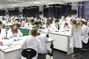
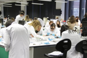
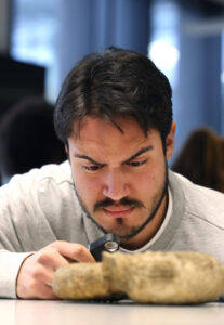
Teaching takes place through a mix of lectures, practical work, workshops, seminars, tutorials and fieldwork, with an emphasis on learning through doing. Students value the learning opportunities provided by field classes, including the rapid and detailed feedback on performance.
You will typically receive 15-20 hours of formal teaching each week, and complete between 50 and 100 days of residential fieldwork over the course of the programme. All research projects are supervised by a member of staff who will meet with you on a weekly, or more frequent, basis.
Field work is carried out in various locations, ranging from inner city to coastal and mountainous environments. We consider applications from prospective students with disabilities on the same basis as all other students, and reasonable adjustments will be considered to address barriers to access.
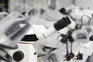
Assessment matches the learning objectives for each module and may take the form of written exams, practical laboratory and computer examinations, coursework submissions in the form of essays, scientific papers, briefing notes or lab/field notebooks, reports and portfolios, oral and poster presentations and contributions to group projects, and problem-solving exercises. Assessment is via tasks that mirror those graduate students are likely to undertake working as professional geoscientists. For example, generating and interpreting quantitative spatial data, with appropriate consideration of inherent uncertainty, is a key task and necessary skill for professional environmental geoscientists, and this skill is developed and assessed on several programme modules, especially field and lab-based modules. As well as being authentic in terms of the underlying purpose of the assessed task, assessment tasks are also authentic in terms of format, intended audience, resources used, and collaborative team elements. For example, team-based environmental assessment work with professional format delivery appropriate for presentation to management-level colleagues using state-of-the-art field, lab or IT resources is central to assessments in field classes.
We have a distinctive approach to education, the Liverpool Curriculum Framework, which focuses on research-connected teaching, active learning, and authentic assessment to ensure our students graduate as digitally fluent and confident global citizens.
Studying with us means you can tailor your degree to suit you. Here's what is available on this course.
Your course will be delivered by the Department of Earth, Ocean and Ecological Sciences. Our unique partnership with the Marine Biological Association allows our students access to their specialist staff, laboratories and equipment. We also have close links with the National Oceanography Centre, and the award-winning Central Teaching Laboratories provides a state-of-the-art facility for practical work.
Want to find out more about student life?
Chat with our student ambassadors and ask any questions you have.
The skills gained through studying a degree in Environmental Science are applicable in many areas of employment, from environmental protection and consultancy, planning and conservation, through to the geotechnical, mineral and energy resource industries, as well as careers in scientific research or academia.
89.5% of environmental sciences students are in work and/or further study 15 months after graduation.
Your tuition fees, how to pay, and other costs to consider.
UK fees (applies to Channel Islands, Isle of Man and Republic of Ireland) | |
---|---|
Full-time place, per year | £9,250 |
Year in industry fee | £1,850 |
Year abroad fee | £1,385 |
International fees | |
---|---|
Full-time place, per year | £26,400 |
Year abroad fee | £13,200 |
Tuition fees cover the cost of your teaching, assessment, operating University facilities such as libraries, IT equipment, and access to academic and personal support.
We understand that budgeting for your time at university is important, and we want to make sure you understand any course-related costs that are not covered by your tuition fee. This includes costs for a lab coat, geological field kit, and sustenance during compulsory field trips.
Find out more about the additional study costs that may apply to this course.
We offer a range of scholarships and bursaries to provide tuition fee discounts and help with living expenses while at university.
Check out our Liverpool Bursary, worth up to £2,000 per year for eligible UK students. Or for international students, our Undergraduate Global Advancement Scholarship offers a tuition fee discount of up to £5,000 for eligible international students starting an undergraduate degree from September 2024.
Discover our full range of undergraduate scholarships and bursaries
The qualifications and exam results you'll need to apply for this course.
My qualifications are from: United Kingdom.
Your qualification | Requirements |
---|---|
A levels |
ABB Including one science Acceptable sciences: Mathematics, Further Mathematics, Physics, Chemistry, Biology, Geology, Geography, Environmental Science, Applied Science, Use of Mathematics. For applicants from England: For science A levels that include the separately graded practical endorsement, a "Pass" is required. Applicants with the Extended Project Qualification (EPQ) are eligible for a reduction in grade requirements. For this course, the offer is BBB with A in the EPQ. You may automatically qualify for reduced entry requirements through our contextual offers scheme. |
T levels |
T levels are not currently accepted. |
GCSE | 4/C in English and 4/C in Mathematics |
BTEC |
BTEC Level 3 Diploma: D*DD in relevant Diploma BTEC National Diploma: DD in relevant subject plus grade B at A level (to include one science) BTEC National Extended Certificate: Distinction plus BB at A level (to include one science) |
International Baccalaureate |
33 overall including two Higher Level sciences and no score less than 4 |
Irish Leaving Certificate | H1, H2, H2, H2, H3, H3 including H2 or above in one science |
Scottish Higher/Advanced Higher |
ABB in Advanced Highers including one science subject |
Welsh Baccalaureate Advanced | Accepted at grade B plus A levels grades AB (including one science) |
Access | Considered if taking a relevant subject. 45 Level 3 credits in graded units, including 30 at Distinction and a further 15 with at least Merit. 15 Distinctions are required in of one science. GCSE English and Mathematics grade C/4 or above also required. |
International qualifications |
Many countries have a different education system to that of the UK, meaning your qualifications may not meet our entry requirements. Completing your Foundation Certificate, such as that offered by the University of Liverpool International College, means you're guaranteed a place on your chosen course. |
Have a question about this course or studying with us? Our dedicated enquiries team can help.
Last updated 10 October 2023 / / Programme terms and conditions