A new era of environmental monitoring is emerging with the unveiling of Dargana, an advanced AI model capable of mapping global tree canopy cover in remarkable detail. The paper, “Dargana: fine-tuning EarthPT for dynamic tree canopy mapping from space,” was presented at the ICLR 2025 workshop on Tackling Climate Change with Machine Learning, marking a major advance in the use of satellite data for conservation and climate research.
Developed by researchers at Aspia Space, led by first-author Michael J. Smith and including LIV.INNO student Ryan Roberts, Dargana is a fine-tuned variant of the EarthPT time-series foundation model. EarthPT is a “Large Observation Model” (LOM) pre-trained on vast amounts of Earth-observation data, analogous in concept to how Large Language Models (LLMs) like GPT are trained on massive text corpora. By fine-tuning this foundational model, the team has created a specialised tool for accurately identifying tree canopy cover and distinguishing between conifer and broadleaved types.
The researchers fine-tuned EarthPT using less than 3% of its original pre-training data and only 5% of the compute required for its initial training. This efficiency demonstrates how general-purpose AI observation models can be rapidly adapted to complex environmental challenges without the cost or time traditionally associated with training models from scratch. Such scalability opens the door to broader, high-resolution monitoring for conservation initiatives worldwide.
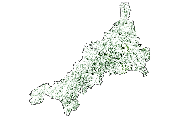
Dargana produces classifications of tree canopy cover at a 10-meter resolution and can track temporal changes, providing near real-time predictions. Tested on tile SX36 - a geospatial coordinate corresponding to Cornwall, UK - the model achieved a pixel-level ROC-AUC of 0.98 and PR-AUC of 0.83 on unseen satellite imagery, underscoring its robustness and generalisability. Beyond its accuracy, Dargana can detect fine structures such as hedgerows and coppice - linear or patch features that play an important role in ecological connectivity - even when these fall below the size of its original training samples.
By proving that Large Observation Models like EarthPT can be efficiently specialised, the Dargana research paves the way for a generation of scalable, AI-driven tools. These tools promise to provide conservationists, policymakers, and scientists with the dynamic, granular data necessary to make informed decisions, ultimately strengthening the world’s defences against biodiversity loss and the accelerating effects of climate change.