Map digitisation and analysis
Digitising historic maps
At the first stage of this project, digital images of the maps were acquired. Links to the British Library (with the main collection of historic maps of Britain), has facilitated ease of access to digital versions of the relevant maps. Next, digital versions of each of the selected maps are being generated. The locations of places are represented as points and, for each of these points, the name, modern grid co-ordinates and other attributes of the location are recorded. In addition, other features such as the coastline, water bodies, roads, administrative boundaries, and other features are digitised in ‘map space’. Once the data capture and development process is complete, the cartographic veracity of each map will be explored in a variety of ways, including through the derivation of distortion grids (see below).
Provisional analyses
To date, the content of several maps has been digitised and provisional analyses have begun. Figure 1 shows the first two maps included in the analysis. The Gough map (c. 1360), or another version of the map known by that name, provided the basis for many later maps of Britain and its content is being compared to a later influential map, the Anglia Figura (c. 1537).
|
Gough map c. 1360; 55 x 116 cm ã Bodleian Library |
Anglia Figura c. 1537 47 x 64 cm ã British Library |
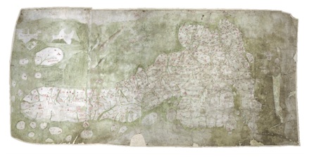
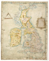
Figure 1. The Gough Map and the Anglia Figura.
Figure 2 shows distortion grids for each map generated using a technique called bidimensional regression. The inputs to this process are co-ordinates of places shown on each of the two maps in modern map space and in ‘map space’. If the grid cells were square they would indicate that the positioning of places on the historic map match exactly the positioning of places on modern maps. So, the more distorted are the cells the less positionally accurate is the corresponding part of the map. The R2 (coefficient of determination) figures indicate the overall ‘goodness of fit’ and values closer to one suggest greater positional accuracy. Thus, the figures suggest that the positioning of places on the Gough Map tends to be more accurate than on the later Anglia Figura. The R2 value for the Gough map vs. Angliae Figura is smaller than for either map compared to modern map space and this suggests that each map is more similar to modern map space than the two maps are to each other.
|
 |
|
Gough map c. 1360 55 x 116 cm vs. NGR R2 = 0.979 |
Angliae Figura c. 1537 47 x 64 cm vs. NGR R2 = 0.972 |
|
Gough map vs. Angliae Figura R2 = 0.955 |
|
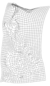
Figure 2. Distortion grids (NGR = national grid references, or modern map space).
This work is being expanded to include a wide variety of additional maps (primarily of the 16th Century). In addition, the team is developing and assessing methods for comparing maps locally to determine which parts of which maps may have been used in later maps and which parts may have been mapped via new surveys. The analysis of other components of the selected maps (coastlines, places included, symbols used, etc) is also being undertaken.