Hydraulics and Erosion Processes
The newly refurbished Hydraulics Laboratory at Liverpool houses dedicated facilities for the study of flow and erosion processes in fluvial, estuarine, coastal and hillslope environments. The laboratory is a joint venture between the Schools of Environmental Science and Engineering, and supports our fundamental research on how water and sediment moves, and our more applied research on how best to manage flooding and erosion.
The Hydraulics Laboratory contains four main facilities:
- Liverpool Coastal Flow Channel. This facility is used to study bed evolution and sediment transport processes in the coastal environment. The channel generates oscillatory flows with periods and amplitudes equivalent to fullscale wave flows and therefore enables wave-generated processes to be studied under controlled conditions.
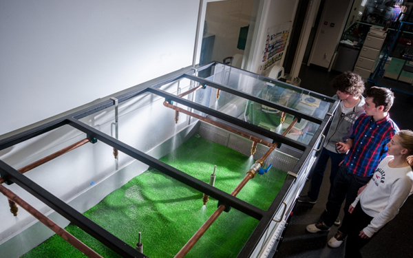
- Liverpool Waves & Currents Channel. This open channel flume is focussed on the study of fluvial and estuarine processes. The flume generates waves and currents independently or in combination, and re-circulates fine sediments. The flume is suitable for the study of sediment transport processes, smooth- and rough-bed hydrodynamics, bed evolution, hydromorphology-ecology interactions and other aspects of fluvial and eco-hydraulics.
- Liverpool Shallow Flow Channel. The facility is used to study runoff and soil erosion processes on hillslopes. The channel generates shallow, overland flows of varying discharge over a range of slopes, and can also be used in combination with our rainfall simulator to produce rainfall-generated flows for the study of splash, interrill and rill erosion. A portable version is also used in erosion experiments at the University’s Ness gardens.
- Liverpool Rainfall Simulator. This facility is designed for carrying out runoff and erosion plot-scale field experiments. The simulator is capable of generating storm events with a variety of rainfall intensities, ranging from low-intensity frontal rain to high-intensity convective storms.
The facilities are supported by state-of-the-art instrumentation for measuring flow velocities, bed topography and sediment transport. This instrumentation includes a LaVision Tomographic PIV, PTV and PLIF system for the detailed study of turbulent flow, individual sediment movement and pollutant transport. We also have an IO Industries Large-scale PIV-PTV system for measuring free surface flow velocities in shallow flows, that has the additional capacity to measure water surface topography using DIC. In addition, the facility houses a host of acoustic equipment for single point velocity and sediment measurement in the lab and in the field (UVP, ADV, ADCP). We also have a pool of topography measurement systems to enable study of the interaction between flow, sediment transport and bed evolution. These range from 3D imaged-based systems for use in the lab (3D camera, SfM) to terrestrial laser scanners for use in the field (Riegl LPM-321 and Focus3D X 330). We also have a range of standard soil science equipment for logging the changes in soil characteristics during rainfall events. To make best use of the rich data that is generated by the Hydraulics Laboratory, we have expertise in CFD and particle-based modelling that can be used to simulate sediment transport and hydraulics of environmental flows.