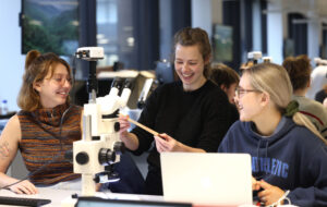
Geographic Data Science
- Study mode
- Full-time
- Part-time
- Duration
- 12 months
- 24 months
- Start date and application deadlines
-
- Start date
- September 2025
- Apply by:
- Starts on:
We've set the country or region your qualifications are from as United Kingdom.
This course will enable you to develop a high level understanding of quantitative and computational geographical methods. This includes skills in GIS software and statistical programming languages, such as R or Python.
Within an applied setting, you will develop skills in the visualisation, modelling and statistical analysis of conventional and novel sources of data, ranging from censuses and social surveys through to satellite imagery and social media using both web-based and traditional techniques.
Human activity is increasingly associated with the generation of large volumes of data. For example, transactional data collated by retailers for marketing and store location purposes, administrative data assembled to help with the efficient running of public services, data shadows created through social media use, and an increased prevalence of smart-card linked transport systems record our travel behaviours.
Many grand human challenges concern problems of a geographical nature; be this how we can mitigate the human impact of climate change; ensure global food and water security; design energy systems that are resilient within the context of future population dynamics; or, how to design future cities where spatial inequities in health and wellbeing might be eradicated. The growing volumes of big data about the form, function and dynamics of human activities are providing new opportunities to advance such debates within a framework of Geographic Data Science.
Please note: We constantly review and develop our postgraduate programmes. This MSc is also available with the alternative title Geographic Data Science MSc for entry September 2025, and gives students the option to graduate with either of these two MSc titles.
This course is for you if you want to understand and analyse the role of geography in everyday life through geographical and computational reasoning.
Discover what you'll learn, what you'll study, and how you'll be taught and assessed.
Our compulsory modules in Geographic Data Science (GDS) will give you a comprehensive introduction to the field where GIS and Data Science intersect. You’ll cover programming with Python, the industry-leading language for GIS packages like Arc/GIS and QGIS.
You’ll also learn about the importance of GDS for social science applications through a combination of lectures, practical classes, and independent study. Another compulsory module delves into using GIS tools to create digital representations of the world, with a focus on avoiding potential problems. Our qualitative research module covers a range of methods and emphasizes the importance of careful research design.
We’ll also introduce you to analysing social survey data through descriptive and inferential statistics, using the R programming language. As for optional modules, we offer a comprehensive overview of key algorithms and approaches for Big Data problems, as well as a focus on database systems and SQL.
Please see below for semester one modules. Select the next tab to view semester two modules.
If ENVS363 or ENVS357 have been taken as part of a first degree, then ENVS563 and ENVS357 cannot be taken and need to be replaced by an additional optional module, subject to the Programme Director’s approval.
If an equivalent to ENVS609 has been taken as part of a first degree, then ENVS609 may be replaced by an additional optional module, subject to the Programme Director’s approval.
No more than five modules can be taken in one semester.
Compulsory modules | Credits |
---|---|
SOCIAL SURVEY ANALYSIS (ENVS450) | 15 |
GEOGRAPHIC DATA SCIENCE (ENVS563) | 15 |
APPLIED GEOGRAPHIC INFORMATION SCIENCE (ENVS609) | 15 |
APPLIED DATA MANAGEMENT AND WRANGLING (ENVS615) | 15 |
Optional modules | Credits |
---|---|
DATABASE AND INFORMATION SYSTEMS (COMP518) | 15 |
BIG DATA ANALYTICS (COMP529) | 15 |
Programme details and modules listed are illustrative only and subject to change.
You will learn about statistical techniques for handling spatial data and the latest debates in the discipline through seminars and essays. They will also gain knowledge of web-based map visualization and analysis, and an understanding of the importance of time and location in new forms of data.
Optional modules give you the chance to learn about biologically inspired optimization, population science theory, and digital trace data analysis. Another module explores social and spatial inequalities and their inter-relations through four themes, providing insight into government responses to these issues in the UK.
No more than five modules can be taken in one semester.
Compulsory modules | Credits |
---|---|
SPATIAL MODELLING FOR DATA SCIENTISTS (ENVS453) | 15 |
WEB MAPPING AND GEOVISUALISATION (ENVS456) | 15 |
POPULATION DATA SCIENCE (ENVS418) | 15 |
Optional modules | Credits |
---|