Could a Leccybus Cure Liverpool's Middle Aged Spread?
Posted on: 11 May 2018 by Ian Wray in Blog
A few days ago an architect friend floated some imaginative ideas for Liverpool city centre. Bring back the One O' Clock Gun, which as late as the 1960s was used by people to set their watches (originally it synchronised ships’ chronometers). The gun could be a nice Pier Head tourist attraction. Get the through traffic out of Rodney Street, the finest Georgian street in the North of England, and widen the pavements. And build a monorail on the line of the old Liverpool overhead railway, connecting up the waterfront. If Chester Zoo can afford a monorail, why not the city centre?
It's the last idea which has really got me thinking. To be honest I'm not sure that anyone will want to stump up the money for a monorail system. But my friend makes an important point about connecting up the waterfront.
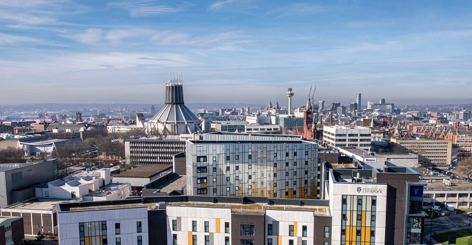
At the moment Liverpool is an easy city centre to get round. Mostly things are close enough together to comfortably walk (though on a wet day I confess that the walk up to the university rather loses its appeal). Nearly everything is near to one or another of the loop link underground stations - that amazing piece of transport investment we got under the wire in the early 1970s, just before the oil price shock and the IMF loan saw off big public investment projects. You can even use the loop link stations to hop from one bit of the centre to another, like a mini underground. That's particularly useful for people who have commuted into Lime Street from further afield.
But the city centre is poised for big changes. Our tight walkable city centre is set to experience some middle age spread. It is moving north up to Stanley Dock, and possibly the new stadium on Bramley Moore Dock, via the Ten Streets regeneration area and Liverpool Waters. If energetic, you can walk from the Pier Head to the Titanic Hotel at Stanley Dock, but I guarantee that, having done it once, you would not repeat the experience. It is likely to be noisy, wet and windy.
Development is also moving east, towards Edge Hill, in the new Knowledge Quarter and into Paddington Village. That is a very long uphill walk for someone who has arrived, say, at Lime Street Station. Understandably the developers would like to see a new heavy rail underground station here, but the costs (probably involving new tunnels in the bedrock) are likely to prove prohibitive.
What’s more, the centre is stretching south into the Baltic Quarter, with so much demand for new housing development here that the council is talking about restraining developers with planning policy, so that other uses don't get squeezed out.
What to do? The obvious answer is some sort of new outer ‘transit loop’ beyond the rail loop link line, tying together the city centre core and the northern, eastern and southern expansion zones. And there are basically three public transit options. You could use a diesel bus service - not particularly attractive, cool, or environmentally friendly, and with very low 'system visibility'. Or you could go for some kind of fixed rail investment - a tram, heavy rail investment, or even that monorail. But the costs are likely to be high and my guess is that such investment could not stack up until most of the development it needs to service has actually been built. So I wonder about a cheaper intermediate technology solution, using electric buses with rubber tyres and power picked up from overhead wires. We used to have this technology. It was called a trolley bus.
If we're clever enough the system could look good, incorporating dedicated bus lanes, bus guidance systems for off road running - and indeed be set up for autonomous vehicles in the medium term. We might be able to incorporate the little used city centre flyover as a dedicated electric bus route. And there seems to be plenty of spare space next to the northern leg of the ring road and along the Strand for other ‘off road’ elements. The route has a certain circular logic: along the waterfront from the Conference Centre to Stanley Dock (thus accessing the Liverpool Waters site); a link to a new heavy rail station on the Southport line near Stanley Dock; then to Lime Street via the flyover; and beyond that up the hill to the university, the new hospital and the Knowledge Quarter. Then it could route back to the waterfront, via the southern edge of Liverpool One and the Baltic Quarter.
By opening up all these new development zones to Lime Street travellers, we would increase the potential for ‘out commuting’ from new city centre housing to jobs in Manchester; and indeed for ‘in commuting’ to Liverpool from all stations to Preston and Manchester. In technical terms we would be considerably extending the city centre's functional labour market area and creating agglomeration economies on a significant scale. And of course the improved transport connections should improve the viability of all those development zones, not least Liverpool Waters and that new Stadium. So far little thought seems to have been given to getting all those football fans to the Stadium.
Those who have long memories will recall that the earliest proposal for Liverpool’s city centre tram project was an electric bus model - and that the main shopping street in Liverpool One was built sufficiently wide to accommodate the tram system that was never built.
It might just work. It's certainly worth looking at in a feasibility study. Obviously we need to give it a cool name and fashionable image. Though Liverpool being the city it is, I suspect it might end up being called the ‘Leccybus’.
Keywords: .