
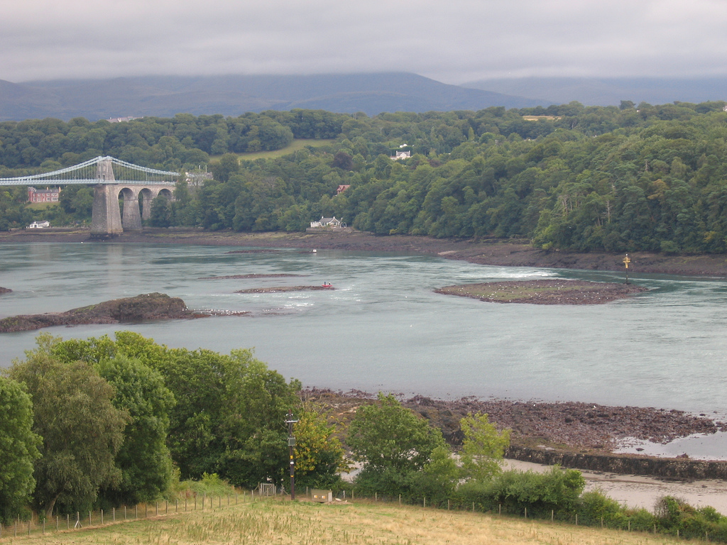
The Swellies is the name of the rocky area of the Menai Straits between the Menai Suspension Bridge and the Britannia road/rail bridge. This area can have a significant tidal height difference between the ends which can cause currents up to 8 knots. Slack water is NOT at HW and LW (but basically almost 2 hours earlier based on HW Liverpool)
I have traversed the Swellies in my boat many times and I have dived there quite often also. At HW slack, the Swellies is a sheltered spot which is easy to navigate using the marks, lights and leading lines provided.
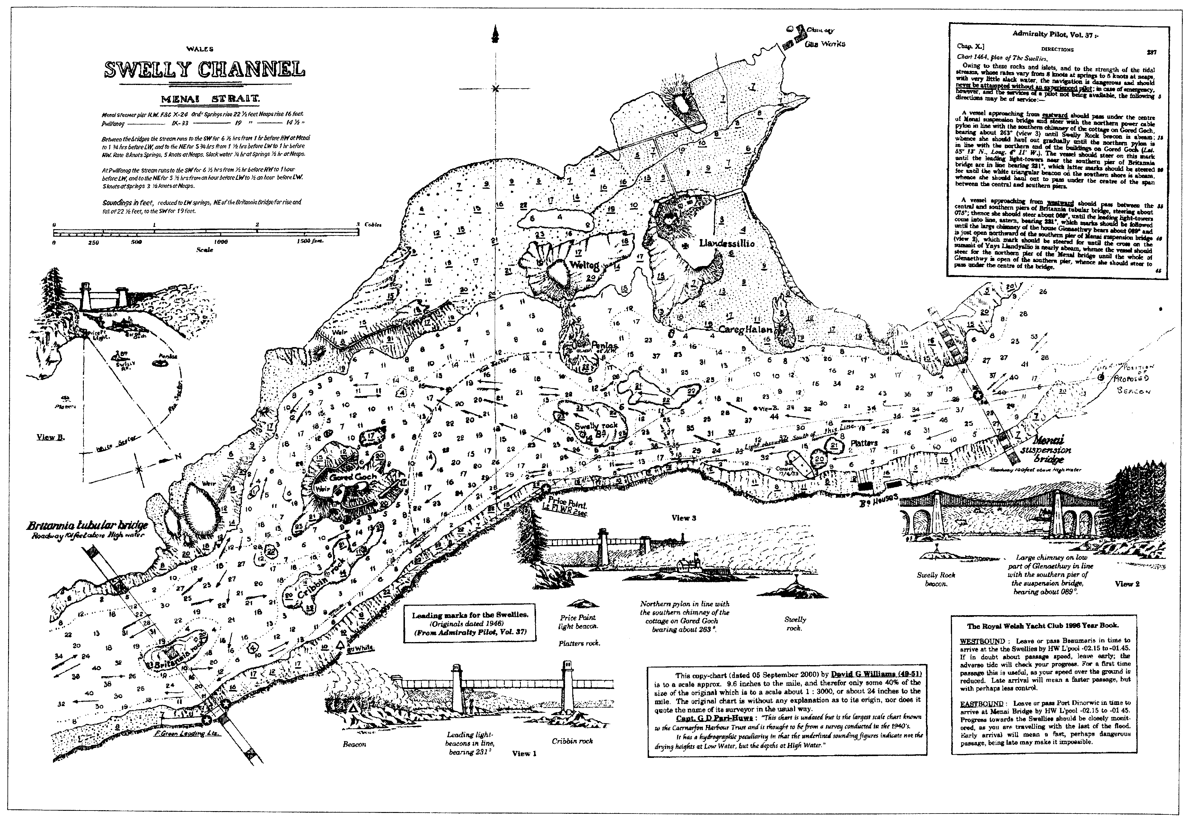
A definitive guide from Caernarfon Harbour Trust is here. This contains a sketch plan of the Swellies:
For some photographs of the rocks, etc at low water see here .
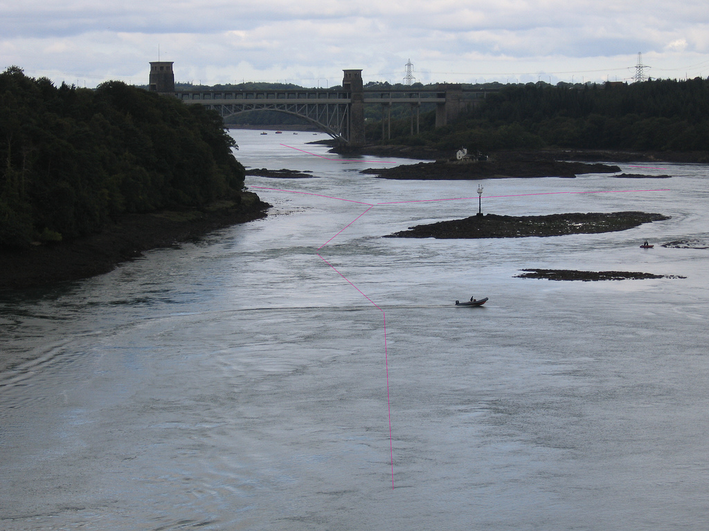
Also LW image of Ynys Benlas
(prominent to left); North Platters (in two parts behind each other);
Platters (behind North platters and near to mainland coast) and Swelly
Rock (to right with beacon).
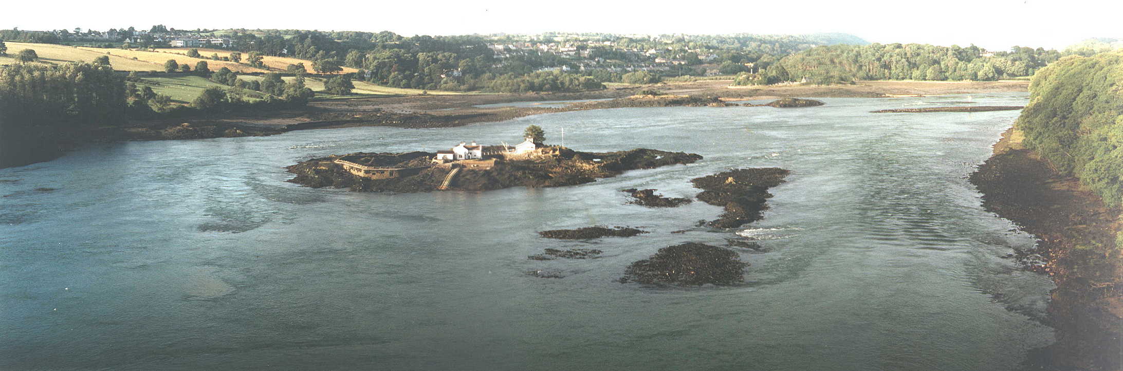
And LW image of Gored Goch
(with cottages); Swelly rock (nearer with beacon) and part of North
Platters (nearest); also Cribbin Rock to left of Gored Goch and another
rocky patch to right of it.
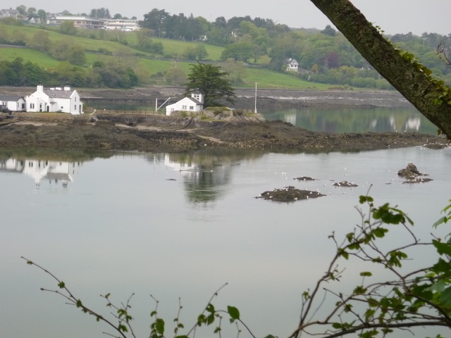
And LW image of Gored Goch
(with cottages) and Cribbin Rock (as several pieces) at LW on a very big
spring tide (Liv 10m). Swelly Rock is at the far right with the North
Platters beyond it.
The basis of the tidal flow in the Swellies is the tidal height
difference between the ends (represented by Pwllfanogl which is just
west of Britannia Bridge and Menai Bridge which is just north of the
suspension bridge). These heights (relative to OD: mean tide level at
Newlyn) are compared for one tidal cycle (12.5 hours) with a simplified
tidal model:

Caption: When the height at Menai Bridge is higher (blue shading) then
current will flow NE to SW and when lower (magenta shading) the other way.
This shows why slack is about an hour or two before HW or LW.
The plot also shows why the tidal current picks up so
quickly after slack water.
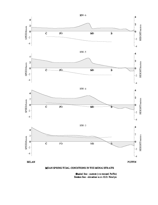
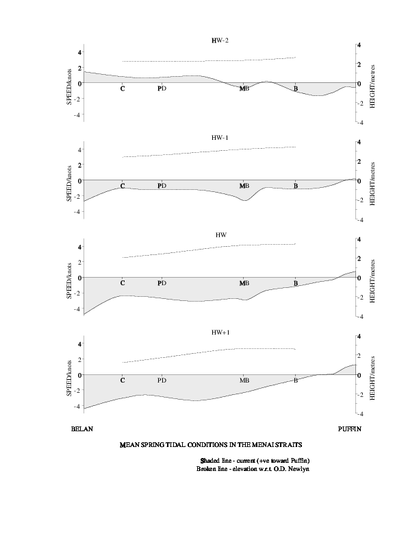
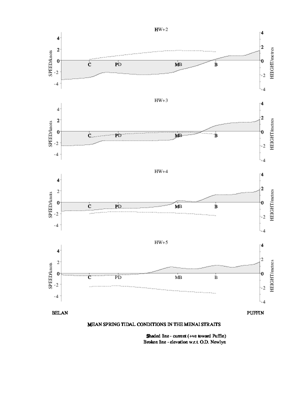
A summary of the tidal currents (positive towards Puffin) and
depths (compared to OD: Mean Tide Level at Newlyn) from
Bangor University at Mean Spring tides, based on HW Liverpool.
For HW-6 to HW-3; HW-2 to HW+1; HW+2 to HW+5. (Click to
enlarge a panel).
 |
 |
 |
A low water passage is quite tricky (especially at springs): I chose to make one recently and on another trip I considered passing though at spring LW . So I decided to survey the Swellies at slack water. See here in 2016. I also added more data from another survey at HW slack here in 2017 which concentrated on Cheese Rock, Cribbin Rock and the east end of Swelly Rock..
My 2016 track (lighter green is shallower):

My conclusion is that the conventional route (as described in the
guides above) has least depth at Cheese Rock (just east of the Britannia
Bridge) and in the narrow channel between the shore and Cribbin Rock.
To estimate the depth above LAT (as charted), I used the tide for Port
Dinorwic (evaluated as given by the Holyhead tide gauge 20 minutes
later). More detail here. The depth
available in these spots then seems to be a bit more than 1m at LAT. As
pointed out by the guides; at Spring LW slack (LW - 2 hours or HW + 4
hours) there will be around 1.6m more depth than at LAT (and before that
time, there will be even more depth).
For a view of Cribbin Rock near LW spring slack [at 4:18 after HW Liverpool of
9.0m with predicted depth at Menai Bridge of 2.3m above CD]
see here
The convention on marine charts is to give depths relative to CD (Chart Datum) which is chosen to coincide with LAT (Lowest Astronomical Tide). At lowest tide level in the Swellies, the current will be running strongly from SW to NE and the tide height may differ by as much as 1 metre across the Swellies. This makes determining LAT tricky. What is used in practice are tide gauge data for Port Dinorwic (CD 3.05m below OD (Ordnance Datum Newlyn)) and for Menai Bridge (CD 3.80m below OD). Then the CD is interpolated between these two locations [detailed prescription not known to me]. This makes the CD for the Swellies about 0.6m below that for Port Dinorwic. That value then should be used to compare my depth values (based on Port Dinorwic) with those on the Hydrographic Office Chart: the charted depths will be 0.6m shallower.
HO chart (2016 version) of shallowest points (with my track as above)

My tracks (distances in metres) for parts of the above area
[near Cribbin Rock and near Cheese Rock] with
colours for depth (metres below LAT) more readable (plus one extra track
from an earlier LW passage):
 |
 |

My Hydrographic Office Chart (corrected to 1986) quotes the survey
for the Swellies as a lead line survey of 1872. Later HO chart editions
contain the same basic information but also show three isolated rocks
(each shown as an asterisk and marked as drying by 1m). I passed close
to these charted isolated rocks and saw no evidence of them at that
depth. Only the isolated rock east of Swelly Rock is of concern taking
the conventional route.
A manuscript survey chart from Pilot Robert Evans
(circa 1910) shows these additional rocks and names them as Llygad y
Pwll (E of Swelly Rock); Nebo (NW of North Platters]; Moch (NE of drying
reef (Carreg Arwyddion) itself NE of Gored Goch) and Garreg Gaws (Cheese Rock).
They are not shown as drying at spring LW.
The later charts also contain different drying heights for Cribbin
Rock (5.7m rather than 4.5m), Swelly Rock (3.7m not 3.1m), the North
Platters (also called East Swelly, 2.9m not 1.1m) and the Platters (2.8m
not 1.0m). As a further guide, the OS map contains a representation of
the MLW line (which is at about CD + 1.5m in the Swellies) and this does
not include the Platters or North Platters: so this implies they must
dry by less than 1.5m: as on the earlier charts.
This conclusion is reinforced by my own observations: at LW
(predicted to be 1.1m above CD at Menai Bridge) neither the Platters or
North Platters were above water - although kelp could be seen growing
on the Platters.
A detailed chart (most probably made in 1948 by Captain Goddard of the Conway training ship when planning to move her from Bangor to a mooring off Plas Newydd) is available here [or here ]. [note this has depths in feet at LW springs but drying heights (underlined) quoted as depth in feet at HW springs].
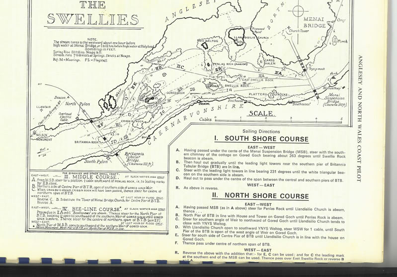
Glazebrooks's sailing directions [Anglesey and North Wales Coast Pilot revised to 1970, one page missing] are available to download - they show 4 possible routes through the Swellies: see map of them .
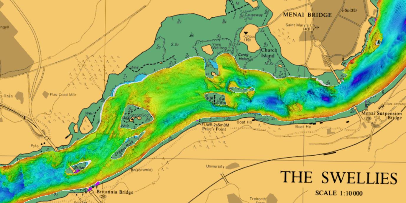
A recent (2012-15) bathymetric scan (multi-beam sonar) of the sea
bed (by SEACAMS) is
illustrated, [also here].
See also a fly-through
of the whole Menai Straits from SEACAMS (depths given relative to
OD - mean tide tevel). Also Swellies aerial view
of seabed.
My survey shows that Cheese Rock is at position 53 12.972 N; 4 10.99
E (marked x in plot above) which is near the northern tip of the bulge
charted with depth marked as 0.4. For a detailed discussion of my
results and the tidal corrections see here.
I find a least depth of about 2.0m at LW spring slack (HW(liv)+4hrs),
but not all the area has been explored.
I also explored some of the other routes through the Swellies: they
have somewhat less depth but may be useful if a large vessel is going
through the conventional (S shore) route.
My (and other tracks with depths) are also available displayed by TeamSurv. This shows Cheese Rock as located near 53 12.97 N; 4 10.98 E with a least depth of about 1.4m. Note that TeamSurv data is based on my (and other) reported echo-sounder depth, whereas in my survey, I have access to the full sonar trace and can check depth more reliably. Also note that data not at slack water will be difficult to translate to depth over CD (LAT) since the tidal height will vary from one end of the Swellies to the other.
Above information is intended as a guide only and should not be relied upon for navigation.
Larger versions of the images can be obtained by clicking on them.
Some historical information: the 1948 Admiralty West Coast of England Pilot gives the above route (close to the mainland shore) through the Swellies and also describes briefly another route keeping close to the Anglesey shore (north of North Platters, Swelly Rock, Gorad Goch and Britannia Rock but going south of Ynys Benlas).
Some earlier historical information: the first sea chart of the
Menai Straits was by Capt. Greenville Collins in 1697. Detail of the
Swellies is shown here (note this is South up):

Back to index