

I mainly use tides favourably (this helps a lot) and motor at my displacement speed (5 to 7 knots). I have an auto-pilot but use a kitchen timer set on 10 minutes (or less) to help me keep a regular look out. I always stop overnight -- since I am single-handed.
Sunday 6 Sept.: Leave Liverpool Marina near HW [18.05 7.8m] at 5.20pm. Pass a big oil tanker (NS Concept) inbound plus several other vessels (one being ship Cosmo - whereas Marlin is known as Cosmo's boat). Leave via Rock Channel, then past wind farms and Great Orme. It had been blowing from the NW for several days and waves of up to 1m had built up. Marlin jumped about a bit, even shipping some sea over the bow, but kept going steadily. The wave height eased after passing the Great Orme. After about 9pm it was dark -- except that the street lights all around the coast illuminated the clouds giving a faint background glow. I anchored in my usual spot south-east of Puffin Island at 11.10pm. The anchorage was quite sheltered. I set a drift alarm (GPS) when anchored which gives peace of mind.
Shipping in the Mersey: NS Concept, MV Cosmo
| |
|
Monday 7 Sept.: as forecast the winds had abated and I set off at
6.40am. This was at about HW Liverpool (6.45 7.6m). I planned to go
through the Menai Straits and the recommended timing is to pass the
Swellies at HW slack (Liv HW-2h). It was a neap tide and I have the
power to counteract any turbulence ("the swurlies"), so I headed in.
With favourable current (4 kts max), I passed Menai Bridge at 7.40, Plas
Newydd at 7.58, Caernarfon at 8.30 and emerged from Caernarfon Bar at
9.10 (so about 2.5 hours from Puffin to Caernarfon C1 buoy).
Llanbedrog: View; Beach; Marlin at anchor
I carried on heading for Maen Mellt (offshore rock) and then
Bardsey Sound (reached at 12.15 with favourable current). I headed east
to St. Tudwals Sound (with some adverse current in places), passing
through at 13.50. I headed for Llanbedrog, arriving in the bay at
2.20pm. The beach had an area marked with white buoys -- which I
assumed meant it was reserved for swimmers. Confusingly the only
swimmers were not inside that area. I headed in to the shore just east
of the buoyed area -- it was sandy and quite shallow (I could see the
bottom clearly) but I managed to get quite close to the shore. I then
anchored and went ashore by tender.
Advice from beach users led me to the pub: the Glyn y Weddw up the
lane from the beach. Refreshment taken, I set off at 3.10pm.
Llanbedrog was a quiet beach: it does not allow cars and trailers on
the beach - which, with the 4kt speed limit, helps to keep speed-boats and
jet-skis away.
 |
 |
 |
My next project was to explore Mochras Lagoon.
This is a narrow inlet giving access to Pensarn and to Shell Island.
The current can be quite strong in the entrance and HW+/-1 is
recommended. I arrived at 5pm. HW was predicted to be at 4.50 (Reeds
based Milford Haven) or 4.28 (local info based Liverpool) and it was a
neap tide. I surveyed the entrance route and passed though the narrow
gap. There are three perches marking the northern side and three small
green buoys marking the southern side. Recommended approach is bearing
186° to the outer (red-topped) perch. There is a dock with
alongside berths to starboard on entering -- a dinghy was tied up there
so I did not risk trying to get alongside. The current was quite
slight, so I was able to turn. After taking a few photographs, I made
my way back out (at 5.15pm).
For more navigational guidance see Google
Map (2009), Llanbedr
and Pensarn YC chartlet and N Cardigan
Bay supplement (downloadable chartlet) of the Ralph Morris Pilot
Book. See also Shell
Island Sail and Power Club.
Mochras Lagoon (Pensarn Yacht Club, the Dock); Harlech castle.
 |
 |
 |
I then headed across to the entrance to Porthmadog. Near HW I was
able to join the buoyed channel at P4 buoy. The channel is well buoyed
but snakes about a lot and is quite narrow in places. There was an
outgoing current of about 0.5kt. I took up a berth on the Madog Yacht
Club visitor pontoon at 6.20 (local HW 4.50 3.4m). On entry I had a
least depth of 1.4 m under my keel.
See also info from a previous visit.
I ate at the Thai Restaurant which is in the Madog Yacht Club
building and then went up to the YC bar when it opened after 7pm (to get
gate codes, pay berthing fee and sample the beer).
It was very calm overnight.
Buoyage (which changes frequently)

Porthmadog: pontoon; dawn, mountains behind.
 |
 |
 |
Tuesday 8 Sept. Set off at 6.20 (local HW 5.33 3.3m). I followed
my incoming track and was out of the buoyed channel by 6.55. I had a
least depth of 1m under my keel - which would have been more if I had
followed the buoyage a bit more closely. It was a cloudless day with
light wind.
I headed in to Criccieth to take a look: the castle on the hill
was conspicuous. It was local HW+ 2h approximately. The harbour was
basically a wall sheltering a slipway and did not have any boats in it.
Criccieth: Castle; harbour wall.
 |
 |
I then carried on to Pwllheli. On the way I passed Pen y Chain: the
headland which used to be part of the Butlin's Holiday Camp. I worked
there in 1960 and have taken the cable car down to the headland. Sadly the
holiday camp is no more - apparently it is a caravan site now. See
more.
I entered Pwllheli Harbour (and Marina). The big pile of
silt/sand just south of the entrance is from the extensive dredging
completed recently.
I took on board fuel at the fuel berth (very efficient service) and then
stopped briefly on the visitor's pontoon to go to the marina office.
Pwllheli: visitors pontoon; dredging pile.
 |
 |
I left Pwllheli at 10.00 am (tide gauge read depth of 2.8m in channel). With a glassy sea, I passed Llanbedrog again and then approached Abersoch. I called up the water-taxi on VHF and they recommended just anchoring close to the beach - since it was calm and there was a sandy seabed. At 11.12am, I anchored close in, just outside the white buoyed area. I rowed the short distance ashore for something to eat in the Beach Cafe. It was very warm and sunny - Mediterranean even.
Abersoch: Beach looking towards Yacht Club, and towards St Tudwals Island.
 |
 |
I left Abersoch at 12.30. I headed for St Tudwal's Sound. Then along the coast past the headlands into Hells Mouth (Porth Neigwl). I anchored up at 1.30pm in the NE corner - to be out of any swell and current. Siesta time.
St Tudwals Island; sea caves (east side of Hells Mouth); Hells Mouth;
 |
 |
 |
Aberdaron: village, beach with Ynys Gwylan Fawr and Fach; view from pub terrace.
 |
 |
 |
I set off again at 5.30pm and headed through Bardsey Sound. Current was 3 kts in a favouarble direction at times. The current west-going can be very strong and Carreg Ddu acts like a ship's bow with a "wake" either side. In calm weather this was visible but not spectacular.
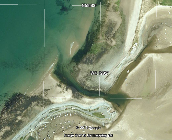
Since the forecast was for force 4-5 SE wind, I had decided to visit
the north coast of Llŷn which would be more sheltered. Possible
anchorages were Porth Dinllaen (which I had used previously) and Porth
Ysgaden. My ETA at Porth Ysgaden was 7.15. There are a lot of fishing
floats around the Llŷn Peninsular, so I wanted to stop before sunset
(8.46). So I decided to explore Porth Ysgaden.
I had discovered this sheltered Cove (the Welsh name translates as
Herring Cove) from the OS map when looking for a shore-dive site back in
1996. This cove has a ruined factory (herring preserving) but otherwise
no houses or farms nearby. There is potential boat launching access
here and some sightseers were parked but otherwise it was deserted.
The HO chart is not accurate, so my memory of diving was a good
guide. HW was at 7.00pm (3.5m) with subsequent LW at 0100 (1.4m). At
(neap) HW the outer rocks were mostly visible and I knew they were quite
steep-to. I anchored in mid channel. The channel is only 40-50m wide so
anchoring with 2 anchors to reduce scope is worthwhile. The holding was
not very good (sand, stones and weed) and it took 2 goes to be happy.
The water was so clear that I could actually see my anchor on the seabed
in 5m depth. There was no current and only a breath of wind. I put out
fenders down to sea-level in case I drifted into the rocks on either
side -- and set my GPS drift alarm. Be aware that pot buoys are often
set in the entrance.
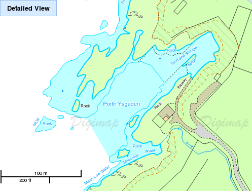
Some images of Porthysgaden from OS
and Google Earth .
The sky was clear and the sunset was spectacular. Later in the
night I turned my anchor light off and looked at the sky. There was no
visible light pollution. The Milky Way was clearly visible. I was
pleasantly surprised by how easy it was to see the rocks by starlight.
I saw a slight glow to the NE and this proved to be the moon rising (a
fingernail moon visible above the cliff at 3.33am). See here for a
night sky image from Porth Ysgaden.
Porth Ysgaden: entrance; setting sun behind outer rocks from anchorage.
 |
 |
Wed 9 Sept. After a calm night, I set off at 7.30 from Porth Ysgaden. I entered Porth Dinllaen at 8.20 - with quite a strong easterly wind causing moored vessels to roll. I decided not to go ashore. Info from a previous visit.
Porth Dinllaen: village; Lifeboat station.
 |
 |
I carried on to Porth Nefyn - which was much more sheltered. I crept in at 8.40 to near the harbour wall with a least depth of 1.2m under my keel. [HW Liverpool 09.23 7.9m]. There was a fishing boat aground inside the harbour wall.
Porth Nefyn: Village; harbour wall.
 |
 |
I then carried along the coast keeping close inshore: past Nant Gwrtheyrn and Trefor. I had done a shore dive at Trefor so knew the pier and harbour.
Quarry workings; Nant Gwrtheyrn; stack on headland S of Trefor.
 |
 |
 |
Trefor: harbour and view including (disused) pier.
 |
 |
I reached Caernarfon Bar at 10.55 with the sea state now less choppy. Bar info. Local HW + 2.5 hours: head in with increasing adverse current as the Belan Narrows were approached (at 11.30). I decided to head on against the current to Caernarfon and tie alongside the Landerne pier (close north-east of marina entrance). This I reached at 12.00 with about 2 kts running past it. I have previous experience of this barnacle-covered pier and its ability to shred hands,.. I managed to tie on at 12.14 and went ashore to Morrisons nearby for their "little breakfast" and coffee. Back aboard and set off at 13.03 by which time the current had slackened.
Caernarfon: Castle; Pier; Marlin on pier.
 |
 |
 |
Plas Newydd; Rail/road Bridge; Suspension Bridge
 |
 |
 |
Head on into the Menai Straits with current dropping until it was slack near Plas Newydd. I went through the Swellies at LW slack: rather fazed to discover 3 paddle-boarders in mid channel. I slowed down as they hastily got to one side. The high speed ribs taking tourists through were also a menace (from their wash).
I had considered stopping briefly at the Pier in Menai Bridge: it
was fully occupied by the historic vessel Balmoral.
Balmoral was built in 1949 as a South Coast Ferry (Southampton -
Isle of Wight) and later used as a passenger ship (P and A Campbell
white funnel line) in the Bristol Channel. She now serves as an
historic passenger ship based in Bristol.
Her size of 60m x 10m x 2m allows her to visit smaller ports. In 2015
she was scheduled to visit Liverpool, Mostyn, Llandudno, Caernarfon
and Menai Bridge. This programme included transiting the Menai Straits.
Because of rough weather, her itinerary was modified and she
was waiting at Menai Bridge Pier when I passed her. I am glad I
did not meet her in the Swellies!
Balmoral tied up to the pier at Menai Bridge; Bangor Pier
 |
 |
With continuing favourable current I passed Beaumaris where
I spotted two porpoises near me. video(mp4).
I passed on the SE side of Puffin Island at 3.10pm: with minimum
depth 2m under my keel, following the waypoints I had established from
previous surveys.
As I came out from the protection of Lavan Sands to cross Conwy Bay, the
SE wind created some wave motion.
This eased off after passing the Great Orme.
I then headed around the coast, through the Rock Channel and up the Mersey to Liverpool Marina by 8.30pm.
All information given in good faith, but please do not rely on it.
Back to index here