


Jump to Piel, Morecambe,
Lancaster, Fleetwood, Blackpool
Tuesday 23 May: leave Liverpool Marina 11:25 (Liv HW 9.40 8.9m) when the
tide levels inside and out were matched: so lock-levelling was very quick. Out
via the shipping channel until ALPHA buoy when I took my shortcut going north at 12:37. Head past
Lennox Rig with views of Blackpool. Current somewhat adverse after heading
north. Join channel into Barrow at 5:13pm near Lightning Knoll buoys. Pick up
mooring off Piel Island at 5:50. Not much sign of life ashore, but I launched
my dinghy and rowed to the slip. Pub was closed and the Ferry was parked
ashore round the back. Website suggested it would be open. Return and eat
aboard. The current incoming picked up strongly later on. Calm overnight.
Blackpool Tower, Piel Castle with Vickers Barrow Shipbuilding beyond, Marlin moored at Piel.
So 6:25 hours Liverpool to Piel, distance run 43.5 nm.
| |
|
|
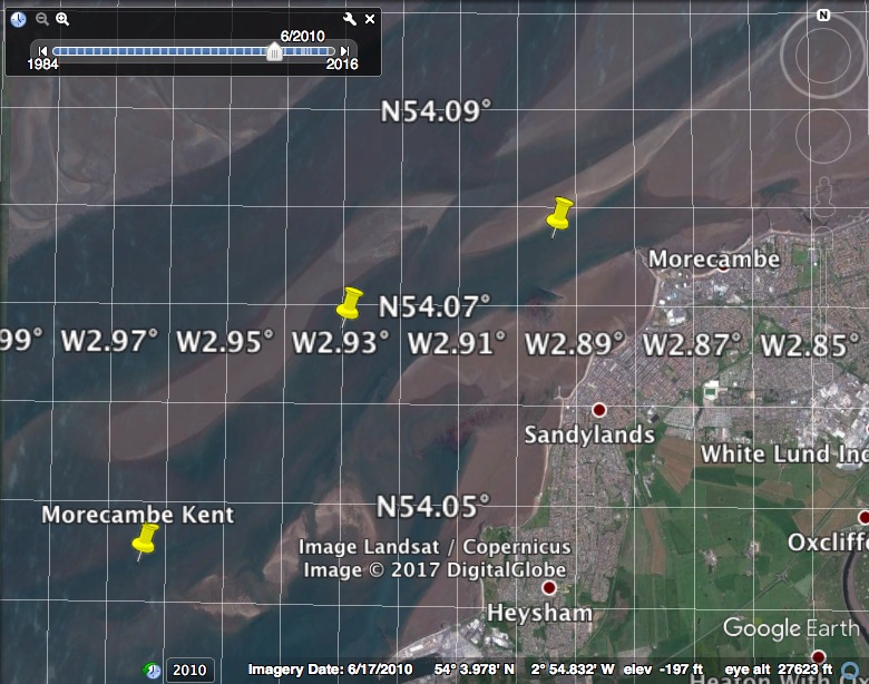
Wednesday 24 May. Liverpool HW 10:32 9.3m. Set off at 6:33 against incoming tide. Cut south across sands (outside Mort and Furness Scar banks) to Lancaster Sound going towards towards Heysham. The chart of this area has regions surveyed at different dates with significant discontinuities where they join. The chart (as of 2017) of the Kent Channel (between Clark Wharf and Clark Wharf Spit) is based on a 1978 survey. North of 54° 03', the chart is based on even older input. I used Google Earth (with option to vary date of view) to show the channel into Morecambe (Kent channel which initially runs SW-NE) and set up some waypoints as shown.
Note these waypoints do not represent the best or deepest route - they are just what I used on one trip.
Reeds gives HW at springs relative to Liverpool in minutes as Morecambe (+10); Heysham (+14), Glasson (+25); Lancaster (+75).
I arrived at MCB1 8:10 (Liv HW - 2:22) and had 3m under my keel proceeding past MCB2 to MCB3. Then passing offshore of the Pipeline buoy, I was at the (commercial) moorings just east of the stone pier and moored in 5.2m at 8:40. There was quite a choppy sea from the NW wind, so I could either wait until after HW when the banks would uncover to provide shelter, move to the leisure moorings which are further east, less deep, and sheltered by groynes or move on. Distance Piel to Morecambe 15.0nm.
Track and depths (depth tidally corrected using Heysham tidegauge, units metres, showing
waypoints) approaching and leaving Morecambe at top right:

Local council mooring info contains images of these two Morecambe mooring areas.
Seals inside Walney Island, Morecambe from the mooring (Midland Hotel in distance), Morecambe moorings near LW (2012)
 |
 |
 |
Advice from local yacht club
MHYC in 2012 is to only
attempt to reach Morecambe after HW-2 and before HW.
I decided to move on (at 8:55) and visit Lancaster. I have an interest in
going up NW rivers to the ancient head of navigation: Warrington on the Mersey; Preston on the Ribble and Chester on the Dee.
I had a plan to add Lancaster to the list. It was a spring tide
which would give more depth, though at the expense of stronger currents.
HW there would be Liv+1:15 and it was Liv-1:37 as I left Morecambe.
With adverse current until I would reach the Lune entrance, I chose to
increase the revs to get round Sunderland Shoulder. I also chose to
explore the shorter route going closer inshore from the Kent Channel to
Half Moon Bay heading south towards Heysham port and Nuclear Power
Station. This has less depth than my entry route but by HW (Liv)-60 it
should be viable - as it was indeed, since I had least depth of 3m under
my keel. This short cut is mentioned as having some stony ground - so
take care if using it.
Half Moon Bay, Heysham (port and Nuclear Power Station), Plover Scar
 |
 |
 |
After passing Heysham at 9:30 (Stena Ferry leaving), I again cut the corner to get into the Lune Channel. I kept outside areas charted as drying more than 4m - which meant I had 5m or more under my keel. I reached the Lune Channel at 10:00 and could reduce revs to my displacement speed. Offshore in this area was the large cable-laying vessel MAERSK CONNECTOR, surrounded by a fleet of smaller boats. She is contracted to work on the Walney Windfarm and its extension.
As I joined the Lune Channel, a coaster BOUNDER (86m long, draught
4.7m, 1984 gt) was inbound to Glasson and I followed her. She was met
by a pilot boat who proceeded ahead of her to show the route. The tight
corner just after Plover Scar seemed tricky for such a size of vessel.
[I since discovered this was accurate - in March 2016 an inbound coaster
hit Plover Scar lighthouse at night and dislodged the base - it was repaired by May
2017 when I passed].
They slowed down near Glasson and I overtook to carry on further
upstream, passing Glasson at 10:25. Glasson actually had a second
coaster HAV DOLPHIN (84m long, draught 4.6m, 2075gt) alongside the usual
quay in the river (upriver from the dock gates). The dock gates were
open (presumably to let the pilot boat out and back in). The dock gates
are currently advertised to open from HW(Liv)-45 to HW(Liv) on the HW
tide of the day nearest to midday.
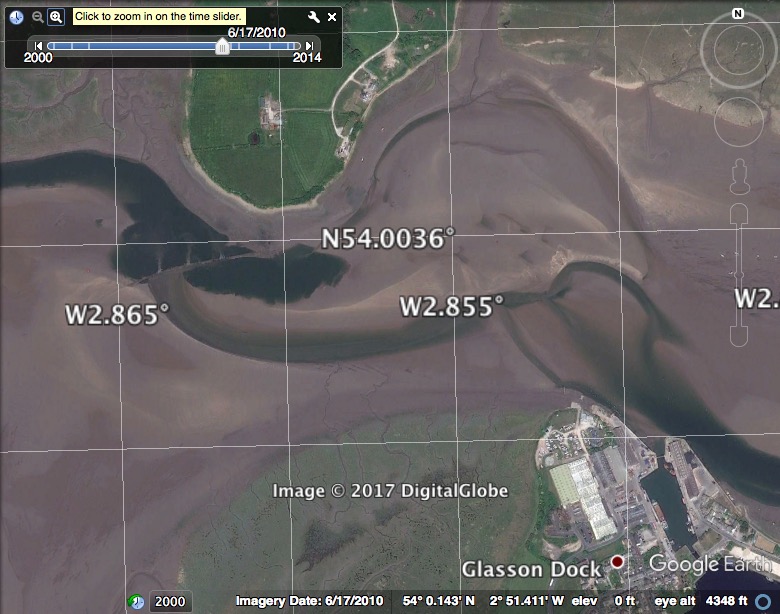
Lune Channel Buoyage up to Glasson: here .
At LW the (ruined) training walls obstruct the passage as shown
here just below Glasson Dock..
Proceeding above Glasson, there is almost no buoyage, but I found
that the charted channel did seem to correspond with deep water. The
chart shows various obstructions: perches, poles and training walls.
There was no sign of most of these at HW, only some pipeline ends were
clearly buoyed.
My printed chart "River Lune and Approaches to Heysham" dated 1989
gives depths in the Lune (quoting landline survey 1871-84) and also
quotes aerial survey of 1986. The latest Navionics chart shows no
depths: just the channel at LW [which seems to be from a 1990 input].
This charted channel has not changed in the last several years but does
differ from that of my paper chart.
By 11:00 I passed the Golden Ball Hotel (at a location called Snatchems
after the possibility that it was used to "snatch" crew by outgoing ships)
where the river turns to starboard. From here on I sometimes had 3m or so
depth under my keel, whereas before I had 4m or more.
Bounder astern approaching Glasson; Lancaster: Carlisle Bridge(viewed from upriver), Millennium Bridge.
 |
 |
 |
I passed under the first bridge: the Carlisle Bridge carrying the West Coast main train line at 11:08, taking the middle arch. This bridge has a large air draught. This opened up a view of Lancaster, with older properties along the quayside. The only boat was a yacht tied up (I also met 1 kayaker on my way up). The next bridge is the Millenium Bridge (locally called "swearing bridge" because of its V-sign appearance). One can just see the Greyhound bridge beyond it. This was built as a rail bridge but now carries a road. It has rather low air draught and is the limit of navigation for boats. I was at Lancaster at around 11:10 (Liv HW+40) which should be before local HW. Current did seem to be ebbing but that might just be the fresh water coming down. Distance run Morecambe to Lancaster 16.1nm. Ironically, by road Morecambe and Lancaster are only a little over 2 miles apart.
Lancaster: quayside(including Custom House), Greyhound Bridge beyond Millenium Bridge; Golden Ball Hotel at Snatchems.
 |
 |
 |
There was no attractive place to tie up with a ladder, so I headed back out at 11:15 using the current to help me along. The Lune is tranquil at HW: swans on the banks, cows grazing, no road or river traffic to be heard. I passed Glasson at 11:55 (HW Liv+1:23) and saw that BOUNDER was tied up to the quay just outside and down river from the dock gates. So there were two coasters tied up at Glasson. I then passed the moorings at Sunderland Point (a village that is cut off at HW since the access road would be underwater then). By 12:45 I was out of the Lune Channel by the Lune no. 1 buoy. Distance Lancaster to off Fleetwood 12.8nm.
Swan on the bank of the Lune, Glasson with BOUNDER alongside, Sunderland Point.
 |
 |
 |
Track and depths (depth tidally corrected using Heysham tidegauge
[so not to Chart Datum in River Lune], units metres) in Morecambe Bay
with Lancaster at far right, Piel at top left and Fleetwood near centre
at bottom:

 |
 |
Since the wind was southerly, the beach to the north of the lighthouse looked sheltered and sandy with wooden groynes. I ran ashore at 1:40pm. As the tide ebbed, I found that I was in soft mud. Good for the boat but not ideal for walking ashore for a meal. I decided to stay aboard and get a siesta.
Views from my location ashore
 |
 |
At some point, I heard someone moving around outside and saw a man
with chest waders climbing along the gullies. He explained that he was
collecting peeler (or soft-shell) shore crabs that shelter in plastic
pipes that he had put in the sides of the gullies where the ebbing water
creates channels. He walked over to my boat - and indeed it was safe to
walk on the mud but very messy. He also volunteered (thanks) to move my
anchor further offshore of the boat (I use it to maintain position as
the boat refloats).
I refloated calmly at 8:30pm. I planned to get back to Liverpool by
midday Thursday, so decided to start off while there was still daylight.
I left Fleetwood via the Wyre Channel (against the current) and was out
by 8:54pm. I then headed just offshore of the sandbanks around to
Blackpool. Heading around North Wharf, there was an area of the bank
still dry (Kings Scar). Heading south I crossed the pipeline (marked by
3 yellow buoys) close inshore: there was a surface disturbance caused by
the pipeline and I detected a subsea bump of a metre or so (at HW Liv-2
hrs there was plenty of depth). I chose to anchor just outside the LW
line off the North Shore (N of the north pier) at 10:25. It was getting
dark but the street lighting illuminated the sea. Fleetwood to
Blackpool 9.9nm.
The forecast was for very light wind overnight. There was a slight swell
left and, unfortunately, it reflected off the seawall to give a somewhat
confused sea. I would have been better off further offshore: but anchoring
with maximum shelter is firmly ingrained. Later on, as the tide fell, it was
very calm.
Thursday 25 May. Liv HW 11.21 9.7m. I awoke at 6am to set off for
Liverpool, hoping to have a good view of Blackpool from close inshore,
compared to my usual route a few miles offshore. Wrong. The calm weather had
created thick fog: visibility was less than 0.5 mile and I could not see land.
With my Radar (chirp technology) I could detect close objects even when the
nearby land gave a big signal. So I set off south along the coast, keeping
clear of piers and pipeline buoys. This area has almost no boat traffic.
Passing the Ribble Gut buoy at 7:45, I could not see it when radar indicated
it was 0.25 nm away. Soon afterwards, the sun broke through and, by the time I
passed the Lennox rig at 8:20, visibility was over a mile.
I approached the Liverpool shipping channel from the north at buoy ALPHA
at 9:12. I called Mersey VTS to inform them of my presence - in case a fog
patch reappeared. They had had a tough morning with thick fog, but by this
time visibility was over a mile. The IOM high speed ferry Manannan passed me in
the channel -- I wouldn't like to be close to her in thick fog.
I locked into Liverpool Marina at 10:30 (just under an hour before HW).
Blackpool to Liverpool 30.4nm.
Manannan at speed in the Liverpool Shipping Channel.
 |
Trip mainly at my displacement speed of 7 knots through the water. Total distance 132nm.
A record of the depth and track of my voyage is available from teamSurv
Clicking on an image should give a higher resolution picture. If even higher resolution versions of the above images are wanted, please contact me. All information given in good faith, but please do not rely on it.
Back to index here
 .
.