Sidescan image:
Mostly reported by windfarm survey circa 2019
Surveyed by MARLIN June
2020,
and dived Sept
2020, Aug 2021
and Sept 2021.
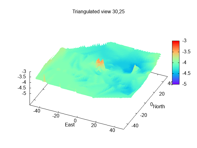
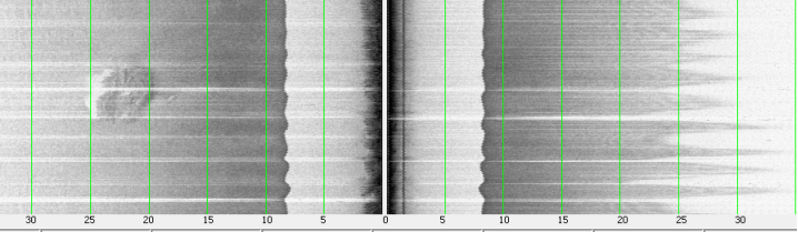
Survey using sonar (downscan and sidescan) and position - to analyse later using tide-gauge results to correct for tidal height and reduce depths to Chart Datum (CD). Depths and distances in metres from waypoint (which is charted position). If parts of the wreckage were not covered by my track - they may not show correctly on the plots which interpolate the measured data. Wreck numbers are for my book-keeping. The word "wreck" is an assumption - these might be obstructions of some other source. But see evidence from diving below.
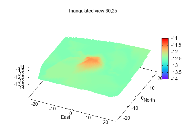
Wreck 1 (Brick wreck)(53° 24.077N, 3° 19.540W; reported 2019 as length
19m, width 5.5m, least depth 3.2m):
Sidescan image:
Dives on 14 Sept 2020.
Video of dive (from DR): here
Sketch of wrecks 1 and 2 (from DR):
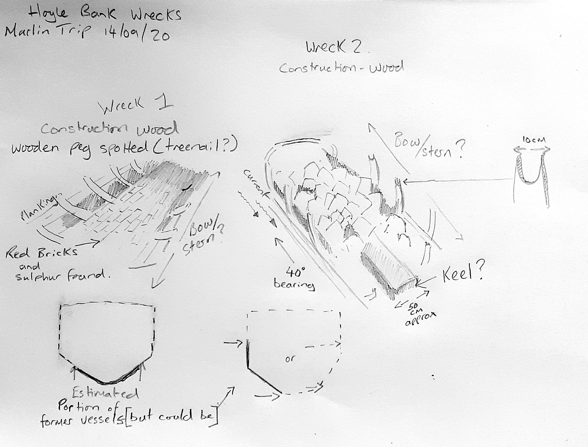
Image of bricks 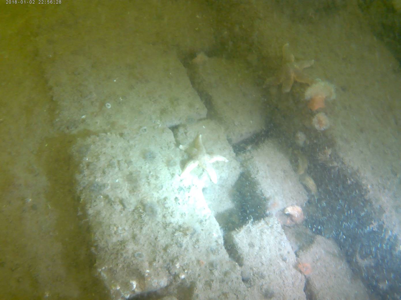
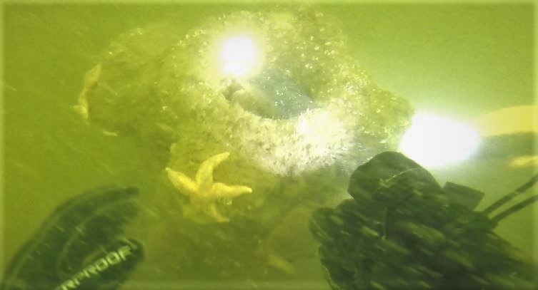
Wreck 1 seems to have a "floor" of bricks - one brick deep - with some other material (sulphurous smelling) in places above it. No sign of bow or stern features. No sign of any metal. Current along wreck (so 150/330°)
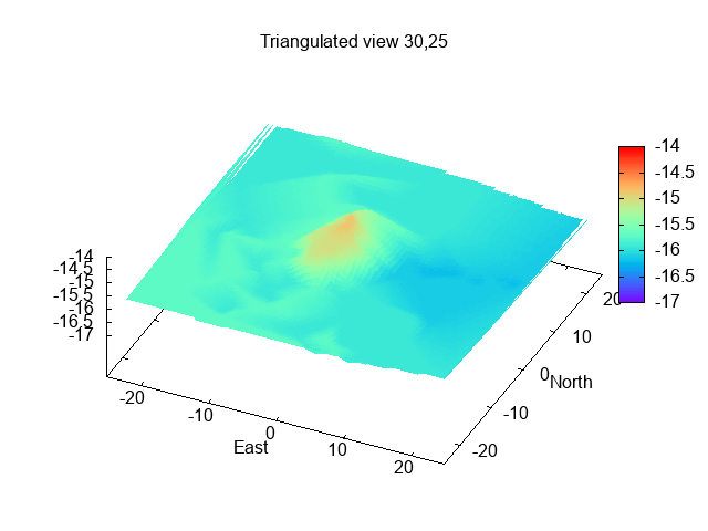
Wreck 2 (stones wreck)(53° 23.669N, 3° 23.071W; reported 2019 as length
18.2m, width 5.2m, least depth 2.9m):
Sidescan image: 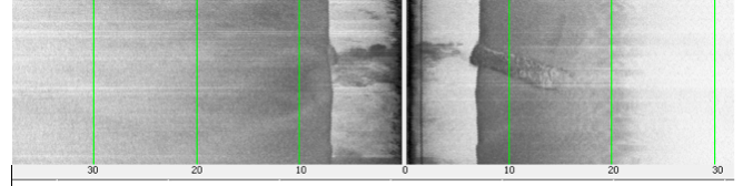
Video of dive (from DR): here
Wreck 2 seems to have cargo of irregular shaped pieces of stone (or similar).
No sign of bow or stern features. No sign of any metal. Current along wreck (so 150/330°)
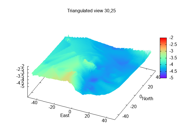
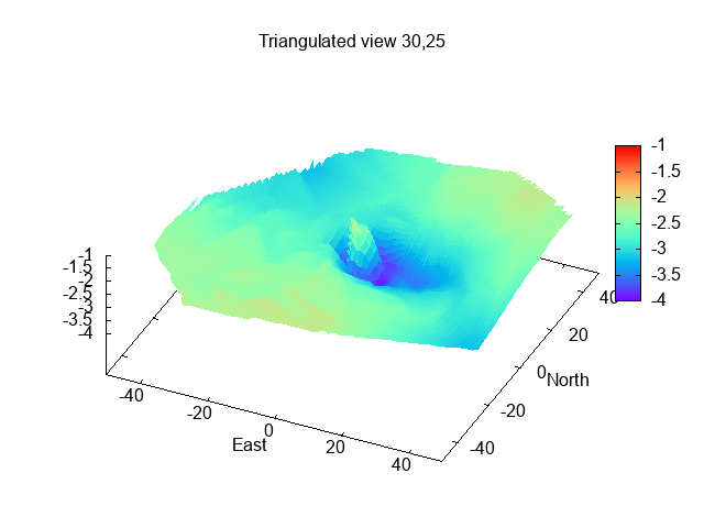
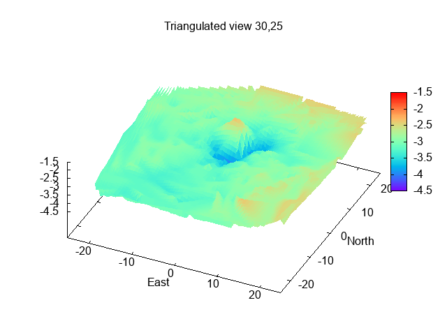
Boiler Wreck: Albion? (53°
23.567N, 3° 22.606W, previously dived by me):
Hydrographic Office info: reported 2000 length
20m, lies 040/220° least depth 0.7m in 1.9m. Revisited 2000: length 27m,
width 8m, height 1.8m, considered to lie in a scour with 2 masts which
protrude above seabed.
Also diver's report: "9.6.10 Dived jun '10 in listed
posn. Found to be a cylindrical boiler, lying n/s, with steam valve
(?smoke collector) as the highest point. No other wreckage visible at this
location. Small, localised magnetic anomaly. Possibly the boiler from a
steam flat (small coaster) with a wooden hull. (C Michael, email dtd 8.6.10)."
My dive was interesting - a large shark-like animal was lying
in the scour around the boiler - at least 6 ft long. Viz was 2m. My
magnetometer survey gave an isolated spike of +500nT.
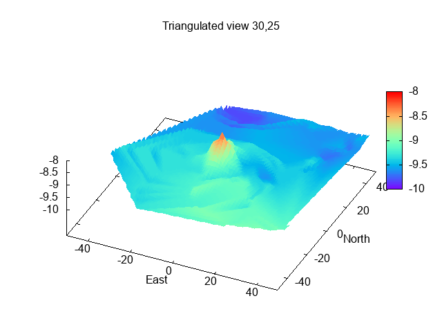
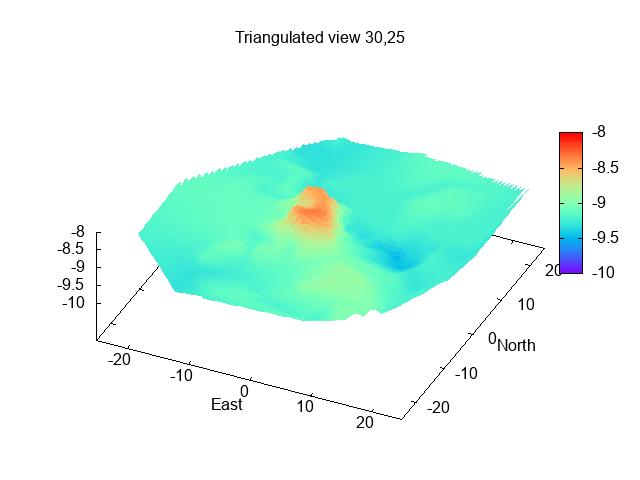
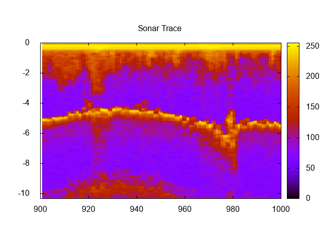
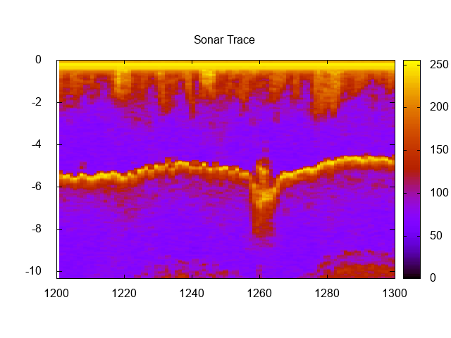
My earlier 2017 sonar scan.
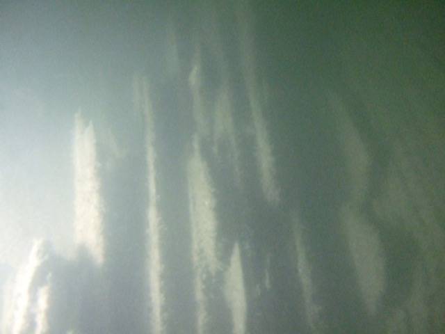
Also two sonar traces (depth not corrected for tide and horizontal axis is
seconds: which corresponds to about 2.5 metres moved each second):
sonar trace 1, sonar trace 2.
2020 sonar scan:
Sketch of boiler wreck (from DR):
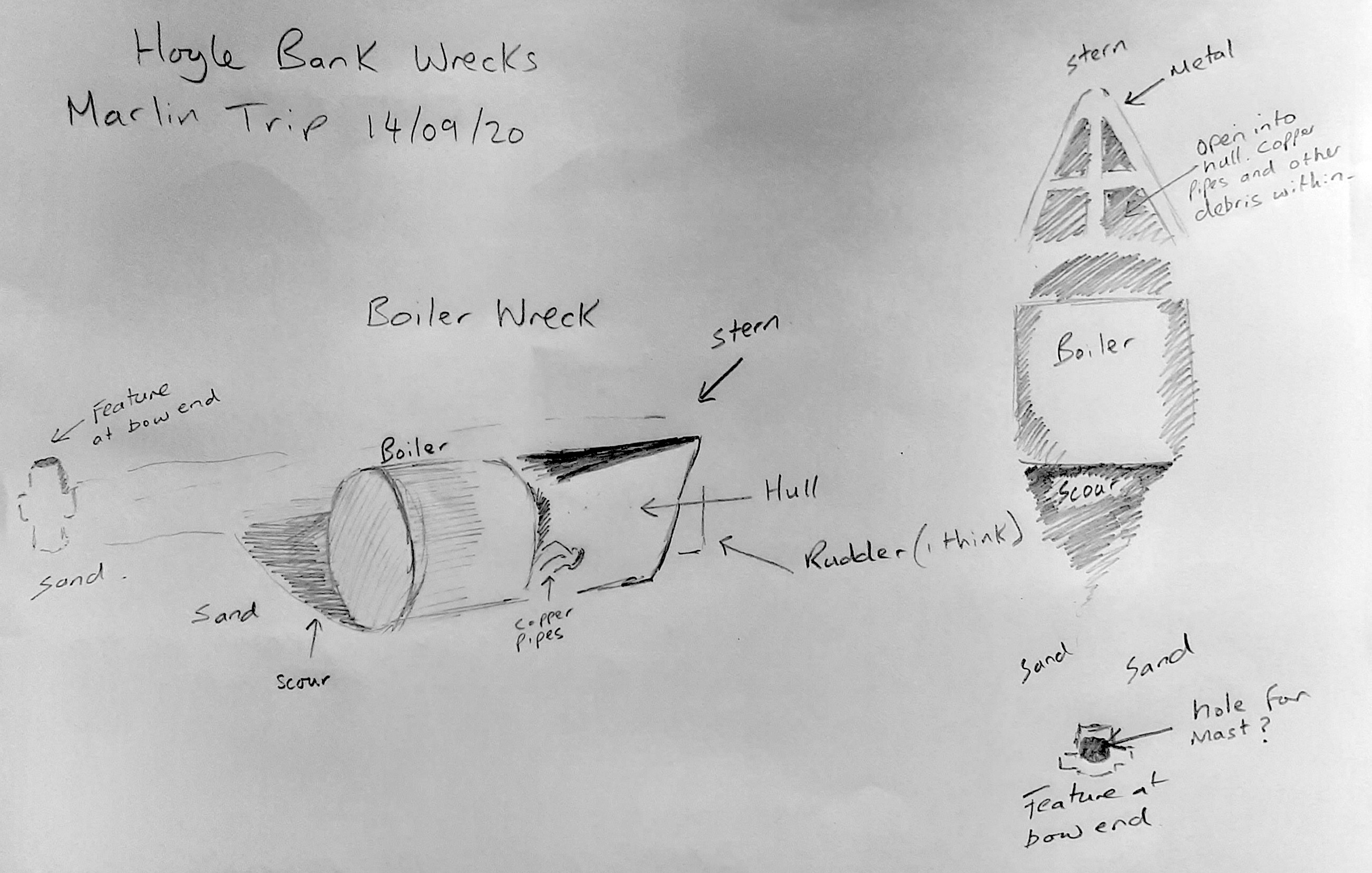
Isolated feature (base of mast?) estimated to be 20m from boiler:
Rudder and propellor at stern. Hold covered in sand.
Video of part of dive (from DR): here
From reports of sinking - the steam barge Renfrew (as well as the wooden steam flat Albion) seems also to be a strong candidate for this wreck.
Dives on 27 Sept 2020.
Wreck 3 (metal wreck)(53° 25.485N, 3° 22.515W; reported 2019 as length
14.8m, width 6.4m, least depth 8.3m):
Reported as containing metal components. Hard to distinguish in poor viz. Some spikey bits.
Video of dive (from DR): here
Wreck 4 (slate wreck)(53° 25.697N, 3° 23.069W; reported 2019 as length
11.2m, width 4.4m, least depth 8.1m):
Reported (PS) as consisting of stacked slates - no sign of remains of vessel.
One slate was measured at 43 x 64 cm - close to the traditional Empress
size (16" x 26"). Image of some slates:
Dives 2 August 2021.
Wreck 5(slate iron wreck)
(53° 26.593N, 3° 24.832W; reported 2019 as length 14.5m, width
5.3m, least depth 11.4m)
Wreck 6(stone slabs wreck)
(53° 27.322N, 3° 26.973W; reported 2019 as length 12.3m, width
4.3m, least depth 14.5m)
NW Hoyle Buoy wreck (stone wreck)
Candidate wrecks:
Wrecks mentioned in newspapers as at no. 136 per chart and not
refloated (these tend to be wrecks which lifeboats - particularly from
Point of Ayr - attended):
Wrecks mentioned in newspapers as at no. 135 per chart:
Wrecks mentioned in newspapers as at no. 129 per chart:
Steam Vessels (and those with metal content):
Details of wrecks of small steamships: Albion and Renfrew.
Paddle steamers wrecked on West Hoyle Bank: Lord Blayney 1833;
Mermaid 1845
Wooden sailing flat Ceylon was carrying a cargo of iron and
scrap metal when it sank on the West Hoyle bank on 17 December 1901 -
see summary and full details.
Slate wrecks:
Wooden sailing flat Anne (ON 78779), first registered at Liverpool
1878, built Winsford
From Lloyd's List 24 and 26 March 1908
Note that another wooden sailing flat, Clara, [see WLB vol II p 83] carrying
slates was lost on 6-2-1895 at a position reported as 3 miles NE of Rhyl
or as between Rhyl and Prestatyn. I had assigned that vessel to the charted
slate wreck at 53°25.299N, 3°30.674W (which I had dived on) and
which is about 5 miles N of Rhyl. But wreck 4 above (slate wreck) could be
the Clara instead - although less likely since it is 7.8 miles at 34° from Rhyl.
Yet another wrecked vessel was reported to be carrying slates: Mary 1792. This vessel
went ashore on the West Hoyle bank, broke up, and part was driven up the Dee estuary.
Tour of outside edge of wreckage was 30 metres [which checks with sonar
reported extent].
Dived 2-8-2021: stacked slates with iron components nearby, also a
large timber beam. Possibly an iron/steel vessel carrying slates. Lots
of sea-life.
Dived 2-8-2021: stacked stone pieces (paving stones?) sticking out
vertically from the seabed (visible ends about 1 foot by 1 inch - length not known
since they were partly under the seabed) with no sign of any vessel.
Wreck identified by survey 2019 at 53°23.491N, 3°24.213W [close NW of
NW Hoyle Buoy in 3.5m - extent 16x8.6 metres]. This was dived in Sept
2021 (report from CH) in poor viz - found to be a pile of stone (most
probably ballast) with some timber pieces protruding.
The West Hoyle Bank is over 6 miles in extent, mainly W-E,
across the mouth of the Dee estuary. Many vessels were reported as lost
on the West Hoyle Bank. The traditional route into Liverpool was via the
Rock Channel, which took vessels quite close to the Hoyle Bank. Also
vessels entering the Dee had to navigate around it.
For a list of some vessels known to be wrecked on the West
Hoyle Bank see wreck list.
From 1802 , Liverpool Dock Board provided (and paid for)
lifeboats. By the 1840s, there were 8: at Formby, Liverpool Pier
Head(2), Magazines (New Brighton), Hoylake, Hilbre and Point of Ayr(2).
Rhyl also had a lifeboat. In 1894, management was passed to the RNLI.
In order to communicate efficiently any rescue requirements, Liverpool
Bay was divided into numbered squares. Then that number could be
telegraphed (either using semaphore, or later electrically) to Lifeboat
Stations which all had a chart of the numbered positions. From about
1850 to 1905, Newspaper reports often refer to these numbers: as "108
per chart" for example.
Wreck 1 is in location no. 129, and both Wreck 2 and Boiler
wreck are in location no. 136. The reported positions (numbers) relied
on coastal observers estimating position, so may be subject to some
imprecision. These numbered squares are quite also large: the above two
examples are 2 x 2 miles. The square 136 is (magnetic) north of 135; and 129 is
(magnetic) north of 128; so those squares are quite close too.
Wrecks 3 and 4 are in deeper water (8m plus) near the
intersection of squares 129,130,136,137. Vessels sunk here will not have
been driven ashore, but foundered or been involved in a collision. It is
less likely that lifeboat records will include these.
Wrecks 5 and 6 are in even deeper water (13m plus) - so unlikely to be
reported unless mast stuck out after sinking.
Note that the small SS Albion is reported to have gone ashore at
no. 108 per chart - which is about 3 miles east of the location of the
Boiler wreck.
Flat Betsy of
Liverpool with coal; February 1869
Schooner Gnu
of Barrow with iron ore; June 1869
Sloop Mona
of Bangor with pig iron; December 1883
Barquentine
Minnie Browne of Glasgow with coal; December 1894
(also here)
Iron Steam Flat Renfrew of Runcorn;
October 1895 [** promising**]
Wooden sailing flat Ceylon (carrying metal scrap) 1901
None found
Owner Thomas Hayes of Liverpool.
Voyage Port Dinorwic to Runcorn with slates.
Foundered 22 March 1908, crew saved in own boat.
Location of loss: 3.5m E 0.5 N (mag) from West Hoyle Buoy: 6 ft of
gaff showing above water
Liverpool, March 23. - The Liverpool trader Dundalk, from Newry,
arrived in
the Mersey yesterday and landed two men and a woman picked up in a boat
outside the bar from the flat Ann[sic], from Port Dinorwic for
Liverpool, with
slates, which had foundered outside the Mersey.
Anne: Liverpool March 24; The Briton(s) from Nevin reports: March 23
about noon about 3.5 m
E 1/2 N (mag) from West Hoyle Buoy, passed the mast
of a vessel, about 3 feet above water, with a gaff attached, showing
about 6
feet, probably belonging to the flat Anne of Liverpool (official number
78,779), sunk on the 22nd March
This position corresponds [roughly, given uncertainty in
location of West Hoyle Buoy at that date] to about 53° 27.0N, 3°
24.6W, which is fairly close to the position of wreck 4 (slate wreck).
The depth of the reported wreck also fits well. So this is a plausible
identification.