MARLIN trip into Dee estuary 6-7 May 2018
Sunday 6 May. High pressure at last. Leave Liverpool Marina at
5:12pm (HW 3:56 pm 7.7m). Calm and sunny. Proceed past New Brighton (at 5:45) and through
Rock Channel.
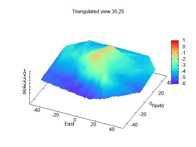
I spent some time surveying a wreck (the Superb most probably) that is
charted as drying 3.9m on the NE side of the Rock Channel. Sonar Image here. I was also
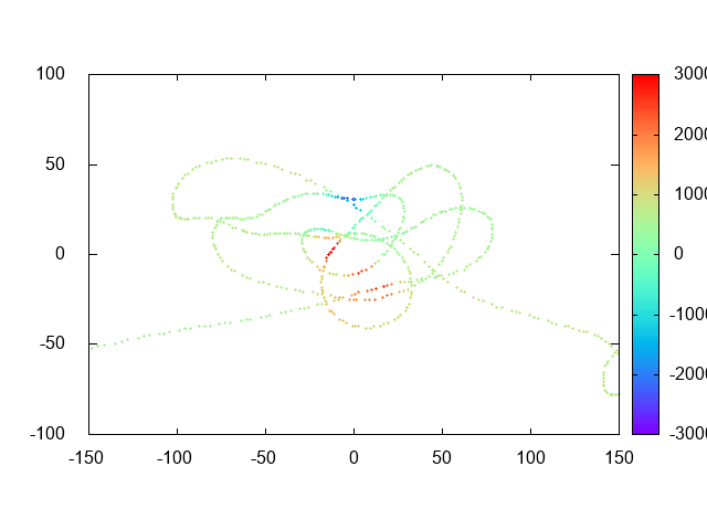
testing my home-built magnetometer. See
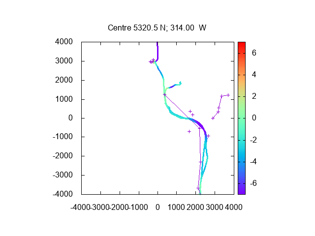
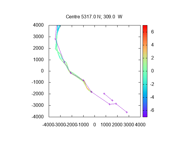
image of magnetic anomaly (in nT versus distances in metres).
I decided to cut across the North Bank, proceeding directly from
Corner to He3. This had least depth of 2.5m under my keel at that tide
state.
After passing HE3, the current was adverse - about 1-2 knots. Pass
Hilbre Point at 7:30 and proceed past He4. The nearby part of the Hoyle
Bank was awash and the seals were lying on top of it.
Hoylake (Red Rocks) with the (phoney) lighthouse in Stanley Road:

Since low water would be at 10:24pm, I decided to anchor for the night. The winds were light and currents were less than usual because of the neap tides. The yacht racing buoys (Seldom Seen, East bar, etc) do not seem to be in place yet. I chose a spot I have used before: just off the entrance to the West Kirby yacht moorings in about 3.5m. I set my drift alarm and had a peaceful night.
Caldy Hill with Cubbins Green
along the shoreline:

Point of Ayr at sunset:

Hilbre Islands at sunset:

Monday 7 May [Bank holiday] (Liverpool HW 4:18 7.7m and 16:50 7.2m).
Sunrise over West Kirby

Sunrise was a 5:30 and it was a clear calm day. I decided to venture up the Dee Estuary until it got too shallow. I have explored this often in the past, but the channel does change - most recently the Dee2 buoy was moved in 2017.
At 6.06 (HW+2 hrs), I moved further into the Dee estuary to check whether the channels available in 2017 were still viable. See here for more info about Dee navigation. I passed my waypoint DeeGut (53 21.174 3 13.672) and found the channel (sometimes called East Bar) to be still viable.
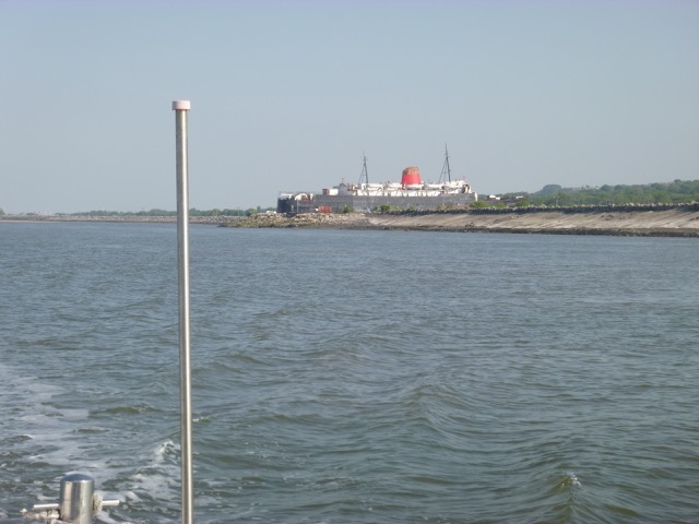
Duke of Lancaster (abandoned ferry at Llanerch y Mor) with Mostyn
Docks at far right. Dee4 buoy in foreground.

I proceeded on to the charted channel past the new Dee2 buoy and then on to Dee3 (green) and Dee4 (green). I passed the Greenfield Gutter and then headed in close to the Welsh coast - passing Dee5, 6, 7 and finally Dee8 by 7:37 where I had only 2.5m under my keel.
Greenfield Gutter

Dee5 buoy

Bagillt Gutter

To be sure to get back out on the falling tide, I turned around there (off Bagillt) and headed out the way I came. In DeeGut I had 2.8m at 8:30 [HW+ 4:10]. At that time, several of the banks were uncovered.
I decided to anchor over LW in the gutter south of the SE corner of Hoyle Bank - near where the seals haul out but not so close as to disturb them. The edge of the Hoyle Bank was dry, so I picked a spot close to it: 53 22.094N 3 14.241W in 1.2m at 8:45. It was calm with no wind and I expected a sea breeze to build up from a NW direction. Wrong. A SE breeze built up - so it was no longer flat calm, though still only with very little waves.
SE corner of Hoyle Bank with He4 buoy to left, seals at tip of bank and Hilbre beyond:

Same view close to low water:

At LW (10:55 3.0m) I still had 0.6m under my keel since the wind pushed me into the deeper gutter close to the Hoyle Bank. Nowhere offshore of the Bank was dry on that tide, although in places it looked shallow.
I decided to set off at 12:22 and I surveyed the area just S to SE of He4 looking for a good spot to dry out on a bigger tide. The SE edge of the Hoyle Bank seems to have moved SE a bit since 2017.
Depths near my anchorage off the edge of Holyle bank.
I passed Hilbre Point at 12:40 and proceeded via He3 to cut across the East Hoyle spit and then the North Bank toward the Rock Channel. I had a least depth of 2.4m crossing the North Bank at 1:50pm.
As I neared Liverpool, I heard Holyhead Coastguard giving information on VHF Channel 16 to lifeguards about reported people stuck in mud on the Formby-Crosby shore. This contained a new offialese to me "the casualties have self-extricated". "Got out by themselves" is a less wordy alternative...
I then entered the Rock Channel (following my waypoints Corner, Chip, Groyne ). I noticed that a racing mark (WYC- white plastic sphere) was laid near waypoint Chip.
New Brighton beaches were packed full - it was the warmest May Bank Holiday on record. A big ACL container ship (Atlantic Sail 296m long, 100430 gtons) was coming in from the main shipping channel and tugs were standing by her.
New Brighton beach on a fine Bank Holiday.

ACL container ship Atlantic Sail and a tug:

I proceeded slowly with the current to wait off the marina and then lock in at 3:30 with 4 other boats.
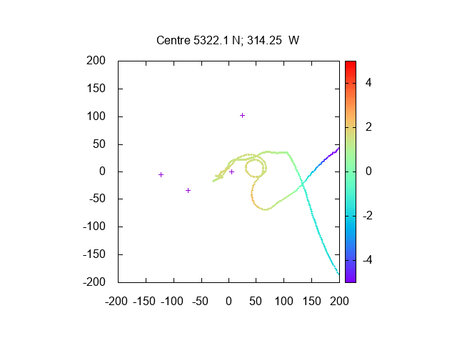
Records of depths on my tracks in the Dee Estuary:
Northern and Southern parts:
Total distance ran about 42 miles, mostly at slow speed (5-7 knots)
through the water.
Tuesday 22 May. High pressure still in charge. Leave Liverpool Marina at
7:13pm (HW 5:55 pm 8.0m). Calm and sunny. Proceed past New Brighton (at 7:40) and through
Rock Channel. Some chop from current against NE wind force 2-3.
A warship under repair at Cammell Laird's pool.
Pier Head.
Tugs waiting on the cruise liner berth.
In my path along the north Wirral coast, there were a collection of
vessels, including 2 jack-up rigs. I checked with Mersey VTS - who just
said "proceed carefully", then called ATLANTIS (a motor hopper - stone
carrier) directly - they confirmed I was OK to pass them close to
seaward. One of the jack-up rigs was called WAVEWALKER 1 - and it does
what it says on the tin. It has 8 legs and can sit up on 4 while it
moves (either forward/back or left/right) for a limited distance, when
it then puts the other four legs down and so can then raise and move the
original 4. See Video .
This enables it to move in shallows or in breaking waves while remaining
up.
The consortium of equipment was clustered around the track of the
Western Interconnector (subsea HV DC electric cables) linking Scotland
with Leasowe on the Wirral coast. This interconnector has been working
at reduced power for a while - but full power tests showed up a fault:
hence the work underway.
Jack-up rigs WIND and WAVEWALKER 1 off Leasowe Lighthouse.
ATLANTIS (with two vertical supports) at right.
As I neared Hoylake, I could see the Hoylake Lifeboat on its
carriage at the waters edge (at right of image)
Round Hilbre Island at 8:50 as the sun was going down.
Sunset (9:15) at anchor off West Kirby.
Wednesday 23 May (Liv HW 6:24 8.2m; LW 13:23 2.2m).
After a calm night, I decided to get up at sunrise (about 5 am) and
set off at 4:50 up the Dee towards Chester. I had previously visited Chester on
a much bigger tide, so this was a trip with less depth.
Sunrise over the Wirral coast:
I crossed from my anchorage across the bank at my waypoint DeeX (near Dee1 buoy) and found plenty of depth.
Then I passed Dee2, Dee3, Dee4, Dee5, Dee6, Dee7 and Dee8 in turn.
Current was favourable and the tide was making.
Bagillt Gutter
Fflint Point (with air draught board for the first bridge).
Fflint Castle.
On my trip earlier in the month (see above), I turned at Dee8 since
depth was getting less. Now I carried on. The yellow buoy which marked
the channel a few years ago is not present, so I tried to follow the
surface ripples which mark the strongest current and hence deeper water.
I headed for the end of the North training wall. I then followed along
the wall until the bank appeared, when I crossed to the Fflint side of
the channel (passing close to the buoyed wreck of the Lord Delamere) as recommended in the
Dee Conservancy Notices to Mariners
Connah's Quay gas-fired power station.
Then under the High level bridge at 6:03.
Passing the wreck of the Audrey
Patricia FV just below Connah's Quay at 6:06 with current still significant
and inwards.
Boats alongside at Connah's Quay.
Passing the wreck of the Unknown Wooden vessel
behind the staging.
Then under three bridges in close succession:
Rail Bridge (no longer swings):
Old (blue - no longer opening) road bridge:
New road Bridge (air draught board shown - this bridge has the
lowest air draught and green means comfortably more than 4m)
Then along the new cut - a long straight section, passing the Airbus
wing-loading facility at 6:31. Here the dredger ARENIG FAWR was squiring
some foul-looking liquid across the river:
Wing loading Bay/Slip:
I passed under Saltney footbridge at 6:37. I had been warned by the
Dee Conservance Harbour Master that there was a sand bar as the river
turned to port at the end of the long straight. He was right: I touched
bottom at 6:52. Since I was going slowly, I managed to back off and
find somewhat deeper water on the extreme outside of the bend. The current
was now less - since the tide had nowhere much to go, although HW at
Chester would not be until 7:24.
Since it was getting shallow I decided to turn around near the Crane
Wharf (now built upon) and the entrance to the Canal Link.
This link has been in the news lately since it features in a plan by the
Rhyl Harbour Master to circumnavigate Wales by sea and canal.
It had been blocked off since 2016 by the EA who put a flood prevention
gate across it. It seems that there is also a silting problem, so the
link will not be open for a while yet.
Canal link entrance - pretty uninviting:
With slight current, I headed back out. By the time I reached the 3
bridges at 7:40, the current was slack and after that it built up
heading out.
Just up river of the rail bridge is what was once a fine building.
The John Summers building on the river Dee, the iconic grade ll listed
building next to Garden City, was built in 1907 - and is now abandoned.
Pass Connah's Quay, the High Level Bridge and the power station.
Near the buoy marking the wreck of the LORD DELAMERE, I had only 0.8m
under my keel. Out along the North traning wall at 8:10.
Perch at end of north training wall
I was followed out by two local trawlers:
When I got out as far as Dee5 buoy, I decided to try to find the
channel from there to Mostyn, passing close to Llanerch y Mor. This is
taken by the Afon Dyfrdwy near HW since it is more direct. The chart
says "buoyed channel" but there are no buoys (except for a single yellow
buoy which seems to be on the S side of the channel). I looked at
Google Earth to see the position - and marked a waypoint where the
channel passes between two sandbanks. At 8:50 (so HW Liv + 2:25 ) I
entered the channel and ran aground. I was unable to back out - though
my propellor did excavate quite a trench. This was firm sand and quite
sheltered so a good place to dry out.
Marlin aground off Llanerch y Mor.
As the tide receeded, I could see that the deeper channel was to the
SW and was quite narrow (looking E and W):
The channel was completely dry by 11:00 (HW liv+3:35). I walked to
the edge of the LW channel and used my GPS to fix a waypoint: 53 18.81N
3 13.01W. I also managed to remove some weed and tidy up generally - in
warm sunny weather.
The drawback of my drying position was that I did not refloat until
later than planned - namely at 4:55 (Liv HW 7:07 8.0m - so HW-2). I
continued with my plan to head to Mostyn, passing close to the Duke of
Lancaster at Llanerch y Mor.
The Duke of Lancaster at Llanerch y Mor.
Approaching Mostyn (at 5:23) I passed some big mooring buoys (marked
RWE NPOWER GYM):
Several pontoons have now been built to allow the windfarm service
boats to come alongside.
AFON DYFRDWY on its "perch" with bow pointing out:
New pontoons at Mostyn:
At 5:24, I left Mostyn:
As well as the Mostyn Channel (M-buoys), a new channel (the Salisbury:
S-buoys) has recently opened up (without dredging) and now seems to be
the preferred channel (buoys S1,..S4). I left along this channel,
passing several incoming windfarm boats. I cut the corner to head east
past West Bar buoy to enter the channel (East Bar) towards Hilbre (at
5:45).
In order to get back into the Mersey before the tide turned, I upped the
revs to do about 9 knots through the water (this is good for the engine).
I passed Hoyle Bank (now covered), Hilbre Point, He3, and headed for
the Rock Channel. The Jack-up rigs and attendant boats were still
working away on the interconnector.
Enter the Mersey at 6:50. Off Albert Dock (Canning Lock), several
tall ships were waiting for the lock. The next few days would be a maritime
festival and start of a tall ships race.
Locked into the marina at 7:13. So 1.5
hours from East Bar to the marina.
Record of my depth and track from this trip and that above (depths
using Liverpool tide gauge 10 minutes earlier: which does not correspond
to CD in upper Dee) and units metres:
Total trip 15nm (Tuesday) plus 51nm (Wednesday).
A record of the depth and track of my voyages are available from
teamSurv
If higher resolution versions of the above images are wanted, please
contact me. All information given in good faith, but please do not
rely on it. Back to index here MARLIN trip into Dee estuary 22-23 May 2018