

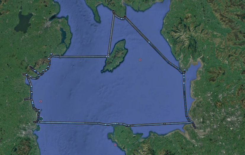
Jump to England (Liverpool) ; Wales (Amlwch); Republic of Ireland (Malahide to Carlingford); Northern Ireland (Warrenpoint to Dundrum) ; Isle of Man (Peel) ; Scotland (Isle of Whithorn) ; England (Piel Island) .
Tuesday 29 May: (Liv HW 11:54 9.0m; 11:10 9.1m) Leave Liverpool marina at 2:00pm. Weather forecast was stable with high to NW and "slack" pressure expected for the next few days. Sunny, E force 3.
Liverpool: vessel on cruise liner terminal; "dazzle" ferry.
Along North Wirral coast where jack-up rigs WIND and WAVERIDER 1 were still working on the repairs to the Western Interconnector off Leasowe.
Then pass the windfarms (North Hoyle, Gwynt y Mor and Rhyl Flats) before approaching Point Lynas. Here the current turned to be against me, so I increased revs for a while.
Control "pod" of Gwynt y Mor windfarm; Point Lynas lighthouse


Enter Amlwch at 8:37pm. I planned to berth in the "pens" if there was room for me. In the
first pen, there was indeed space and I slowly crept in. There were several people on the
quayside and I asked them if it would be OK to berth alongside John Shaw's catamaran SeeKat C.
One of them replied: yes and that he was John Shaw (he had been doing some work on his boat).
I have met John several times and we have a shared interest in diving,
shipwrecks and boating. He gave me a lift to the pub (Adelphi Vaults) where
we had an interesting chat. The current landlord is himself a diver and runs a
dive shop (Amlwch Diving Services) nearby.
John also alerted me to the progress being made in installing an innovative "wing" device called Deep Green to extract electric power from the sea current in the deep 6 miles west of South Stack. The surface component of this test facility is a substantial yellow metal buoy (micro grid system: MGS) - and this is now installed. For details see here.
Liverpool to Amlwch 47.5nm.
MARLIN in the "pen" at Amlwch; sunrise over the Skerries (with lighthouse).


Wednesday 30 May (Liv HW 12:30 8.9m; 00:45 9.1m)
To catch the west-going tide, I needed to get up early. So set off at 4:16. There was a prominent full moon as well as some light from the sun below the horizon. Because of the traffic separation zone NW of the Skerries, I headed north of Ethel rock, then north of the Skerries and then crossed the TSZ at right-angles as prescribed.
From then on it was a straight line to a waypoint off Malahide (destination chosen since it advertises fuel available by hose 24 hours a day). I have previously found some difficulty in getting fuel in Ireland: locals seem to fuel up from a road tanker - but this is not suitable for a cruising boat seeking a fill on arrival.
To arrive in good time, I increased revs for a few hours (doing a little less than 10 knots through the water) and arrived at Malahide marina at 12:00. The fuel berth is not in the marina, but beyond the marina in the lift-out bay. After a delay in getting the key, I was fuelled up and left at 12:45.
Amlwch to Malahide 65nm.
I have been to Malahide long ago
(in my previous boat) but had never ventured along the coast north from there
- so that was the plan this time. Unfortunately, many of the possible
destinations are only accessible near HW - and I had only one HW a day to use,
since I stop for the night.
Sources of information are Reeds Almanac, Irish Cruising Club's Sailing
Directions for East and North Coasts of Ireland (Revised 2018), E-Oceanic
web-site and local port and harbour authority web-sites.
One all-tide option was Drogheda ("gh" silent) since it is a commercial port and has recently improved the berthing facility for visiting boats ( Fiddle case Pier). See also here .
Leaving Malahide; Lambay Island.


I headed north along the coast - with quite a few Martello Towers visible. Lambay Island (inhabited but not welcoming to visitors) was visible offshore. Fishing floats are a problem. The Irish coast seems to have more poorly marked fishing floats than elsewhere. I saw several that were just a single blue 20 litre plastic container - hard to see even in calm weather. Some had white plastic containers that were equally hard to see if there would be white horses. You really can't relax in coastal waters because of the threat of rope from these floats getting around the propeller.
In order to get a rest, I decided to visit Loughshinny (not to be confused
with Lough Swilly). This has a pier which should have a little water at its
end at LW. I entered the bay - confused by a large green buoy which seemed to
be protecting some lines of floats (shellfish storage or farming?). See also here .
I anchored in the bay from 2:30 to 4:30 for my siesta.
Loughshinny: Martello Tower; Quay.


Loughshinny: my track (lighter is shallower).

I then continued up the coast to the town of Skerries - with its cluster of offshore islands and reefs. I entered the harbour at 5:23 (not long before LW). There is supposed to be 1.5m depth at the pier head at low water - and I turned around at 5:30 after taking photos.
Rockabill (offshore of Skerries with lighthouse)

Skerries Quay (near LW).

Next port of call was Balbriggan which is supposed to dry beyond the harbour entrance. Indeed it was dry close to the entrance when I came close in (at 6:00).
Balbriggan Harbour access (at LW).

My primary destination was Drogheda since it is accessible at LW and has recently invested in a pier for visiting boats as discussed above. A coaster SARAH-B was anchored off, but I entered at 7:08 (close to local LW time). It was calm with almost no current, so I could follow the well-buoyed River Boyne channel in. There was no other shipping at that time. I passed the trawler berths, the quay with coasters alongside (ROMI and MERIT) at 7:34 with the port office (pilot boat etc) opposite. Up to the commercial quay (and turning area) the channel is maintained at 2.2m depth at spring LW and I found I had plenty of depth and above that at 1.3m according to the Port Authority.
I found enough depth to continue up under the railway viaduct (with barge/dredger ARGUS moored close by) to the town quay. The Fiddle Case Pier on the north bank is not really a "pier" since it only sticks out enough to avoid the debris at the bank of the river. It has stout pillars with ladders and a new platform on top. I tied up at 8:00 with 1.2m under my keel. Some locals helped to take my lines around the bollards. I put out as many fenders as I could and tied up so that I would still be close by at HW.
Malahide to Drogheda 29.1nm.
A visit to the town nearby provided a chicken kebab and a drink at the Mariners (which had nautical artefacts including diving gear). It was mirror calm and the current in the river was quite weak.
During the night, I heard some rope "singing" and got up to find one of my lines had
snagged at HW and was under tension as the tide went out. This was fixed just in time.
The only other vessel tied up in the town quay area was a large dredger HEBBLE SAND
that looked very decrepit.
Drogheda entrance channel: Stone mark; trawler berth.


Drogheda entrance channel: Coasters alongside; pilot boat berth (with
pilot boat Boyne Havelock and workboat tender Boyne Protector).


Drogheda entrance channel: Barge; rail viaduct.


Drogheda: Marlin alongside; Fiddle Case Pier


Drogheda: Looking out from foot bridge.

Drogheda: Dredger alongside; old and new navigational marks.


Thursday 31 May (Liv HW 13:06 8.8m, 01:19 9.0m).
Leave Drogheda a little after LW at 7:20 with 2m under my keel (minimum
during night was 0.7m). Out of river by 8:25.
I visited Port Oriel (9:15) which is an all-tide fishing harbour near
Clogher Head. The harbour has no food or drink options without a longish walk.
After photos, I left for Dundalk which can be entered after half-tide.
Clogher Head (with seal).

At 10:45, I entered the channel up the Castletown River to Dundalk. This is again a working commercial port and has good buoyage. In calm weather, I reached Soldier's Point by 11:15 and was tied up at the quay by 11:33. There were some fishing vessels rafted up and the locals on the quay said it was OK to come alongside one (DK51) for a short stay. There is a significant cockle fishery in Dundalk bay - with cockles gathered by boat using dredge or suction. My alongside location was close to the stern of a big coaster RODAU that was loading scrap iron.
Local advice was that there was a supermarket (Lidl) nearby - so I topped up my food store.
Dundalk: Commercial quay with RODAU loading scrap iron and trawlers beyond;
MARLIN alongside trawler DK51.


Dundalk: View of mountains around Carlingford

I set off again at 12:30, nearer to HW. My next visit was to
Giles (also Gyles) Quay: a pier that dries to its head. There were two fishing
vessels tied up and I managed to squeeze in between them alongside at 2:00. The
skipper of one of the fishing vessels came to talk to me - he was two years
older than me and set out alone in his cockle dredging boat - which he had
built himself 30 years ago.
The other attraction of the site was a bevvy of beauties sunbathing (and jumping in)
on the quay. The wall provided shelter from the onshore breeze and was a suntrap.
The only source of supplies at Giles Quay was from a shop on a nearby caravan site,
I was told.
I took a siesta until 3:00 (depth 1.9m under my keel when alongside) when I set off around to Carlingford Lough. I entered using the Hoskyn Channel and passed the prominent lighthouse Haulbowline (name thought to be from Norse for conger eel dwelling) at 4:25. I have previously visited Carlingford Lough: when I stayed in Carlingford Marina overnight,
Giles Quay: View each way from MARLIN.


Giles Quay: friendly bird (black guillemot):

Carlingford Lough: Haulbowline lighthouse; Greenore-Greencastle Ferry FRAZER MARINER crossing
(service started 2017).


Carlingford Lough: Greenore with PACIFIC HURON (dry bulk cargo 190m long)
unloading; SeaTruck PANORAMA (142m long) overtaking me.


After passing through the narrows (between Greenore and Greencastle) with 2.5 knot adverse current, I reached the wider expanse of Carlingford Lough. I have previously visited Carlingford Marina, so decided to carry on up to Warrenpoint.
One interesting link is that an early steamship, the LORD BLAYNEY, was on a passage Warrenpoint to Liverpool when she was lost with all hands (and without trace) on the Hoyle Bank off the Dee Estuary. I have seen a report that she may appear as a ghost ship in Carlingford Lough.
The Heysham-Warrenpoint RoRoFerry passed me and then I could see her turn off Warrenpoint to back into her berth.
Drogheda to Warrenpoint 48.4nm.
I called Warrenpoint Harbour Radio as required and they indicated that I would be met on the pontoon. Here I got a bit confused: I had not fully realised that there were two different berthing pontoons at Warrenpoint: the short pontoon behind the outer breakwater is run by the Council and has no facilities or security, whereas the Town Dock now has a marina run by the Port Authority with gated access and facilities.
After first visiting the breakwater pontoon (the end of which is apparently used by the Omeagh-Warrenpoint passenger ferry), I then moved to the town dock marina which now has a separate visitors pontoon at the S corner. This was located aft of the large mussel dredger WINGS OF THE MORNING N210 which was berthed on the quayside. I was shown how to exit/enter the security gate and where the toilet/shower facilities were. There seemed to be no other visitor at that time. See here.
Following local advice, I ate (and had a beer) at the Lough and Quay and then went for a walk around the town.
It was calm overnight, except for a horrible noise around 5am which proved to be the Seatruck ferry turning with her propellor directing water into the Town Dock.
Warrenpoint: Marina; Marlin alongside.


Warrenpoint: Breakwater with pontoon; View down Carlingford Lough.


Friday 1 June (Liv HW 01:19 9.0m, 13:40 8.7m).
I left at 7:14 and proceeded out along the charted channel. It was misty with no wind. I was at the open sea by 8:35 and then passed outside the Hellyhunter rocks to Kilkeel. I entered Kilkeel at 9:15 (local LW 7:53 1.1m) and had enough depth to go up to the far end of the harbour where there are pontoons. The harbour was full of fishing vessels - many rafted together. I left by 9:33.
Kilkeel: Views of fishing vessels alongside and at pontoon.


My next visit was to Annalong. This harbour used to be a favourable port of
call with a pontoon in the inner harbour close to the Harbour Inn. Storm damage to
the storm gates, pontoon and walls has not been repaired. The current status of the
harbour is unclear - although local boats are still using it.
I proceeded in at 10:30 and tied alongside in the outer harbour. This had 2.2m
under my keel at that time. I climbed the ladder to look around. The remnants of the
storm gate mechanism were still visible and fenced off. The pontoon ramp was stored
on the quayside but the pontoon support poles appeared to be still present.
It is a shame that this pleasant spot is no longer as welcoming to visitors as it was.
Annalong: Entrance; Marlin alongside in outer harbour with mill beyond (also back guillemot).


Annalong: Inner harbour.

My next port of call was Newcastle. This is a holiday resort with a drying harbour at its southern end. The harbour dries by 1m but HW was approaching so it was safe to enter on a making tide. Some locals on the pierhead directed me to a suitable alongside berth at 12:07 in 1.7m under my keel. They also suggested a suitable cafe: Olive Bizarre. This was not far away, although there was some rain, and proved a good choice. The highlight for me was the toilet which had a "only gnomes allowed" sign on it and was copiously decorated with little men, toadstools, etc. I left Newcastle at 12:57.
Newcastle: harbour approach.

Newcastle: Marlin alongside; view of harbour.


My last destination in Northern Ireland was Dundrum. This was a commercial port but has closed and the quayside is now full of flats and houses. It is approached by a channel between sand dunes which is not buoyed. On one bank of the channel is Ballykinler firing range. I entered the channel at 1:25 (local HW 2:07 4.5m) with some ingoing current. I tried to follow the surface disturbance to get the deeper part of the channel. By 1:36 I was into the wider area in front of Dundrum itself. As no alongside berth was apparent, I turned and went back out (by 1:50) passing the seals that congregate there since the firing range keeps people and dogs away. This (with nearby Strangford Lough) is the only significant site where Common Seals are found in the Irish Sea.
Dundrum: Entrance channel (looking out); Town.


Dundrum: Seals on Ballykinler side of entrance Channel.

My track into and out of Dundrum (lighter is shallower).

As I went east from Dundrum, I crossed the Ballykinler Firing range. I have
some issues with these firing ranges. One
advantage, however, is that there were no fishing floats in the area.
This area (the beach south of Tyrella, inshore of the Cow and Calf Rocks)
was where the SS Great Britain was stranded for a year in 1846 after mistaking
St. Johns Lighthouse for Chicken Rock on the Isle of Man. The refloating of
the vessel was an epic endeavour: see painting of her
aground.
I passed St. John's Lighthouse at 2:40 and headed to Peel on the Isle of Man
St. John's Point Lighthouse.

Visibility crossing from Northern Ireland to the Isle of Man was hard to estimate
since the seamist made the horizon invisible. Using radar and AIS, I could evaluate
distances and I could see large vessels at 1-2 miles away. It was very calm.
I approached Peel at 7:30 (close to local LW at 7:57 1.0m). Alongside the
outer pier, there were many vessels tied up. The outermost were two
Kirkcudbright trawlers and I asked a crewman aboard if I might tie alongside
for a hour or two. This was agreed (thanks Emmanuel) and I duly clambered
across the trawlers (nearest was scallop dredger ACADEMUS BA817) to climb up
the quayside. Then I walked into town to get a drink. It was very busy (TT
race practices) but the public bar of the Peveril was not too full and I had a
drink there.
I was back aboard at 8:25 and took up a mooring off Peel. This was quieter than the
Pier and the weather was calm.
Warrenpoint to Peel 72.6nm.
Peel: Marlin alongside fishing boats on pier


Peel castle from my mooring.

Saturday 2 June (Liv HW 01:54 8.9m 14:15 8.5m).
I set off from Peel at 6:00 in calm weather, heading for Scotland. I wanted to visit Port William since I had not been there before, even though it would most probably be inaccessible until near HW. By 9:35 I could see the drying rocks (Scares) that lie across the mouth of Luce Bay. This Bay is a firing (bombing?) range and has buoys marking the edges of the designated range. I passed DZ6 then DZ5 to approach Port William.
Indeed Port William harbour looked pretty much dry and I decided not to anchor off and row in, but to continue to Isle of Whithorn which is readily accessible 3 hours either side of HW. There was a heavy shower of rain but still almost no wind. I reached Isle of Whithorn by 12:17 and had just enough water to reach the visitors berth in the corner of the harbour. This was a good time to visit the Steam Packet Hotel for a meal and drink. This is located directly on the quayside near the visitors berth.
At 1:05 I left, heading for Barrow (Piel Island).
Scares rocks in Luce Bay; Port William at LW.


Isle of Whithorn: views along harbour walls (half tide).


I entered the main Barrow shipping channel near Hawes Point and was moored at Piel Island by 9:42. I did not go ashore.
Peel to Piel (via Scotland) 106.1 nm.
Piel Island: Castle and Pub:


Seals on Walney Island:

Sunday 3 June (liv HW 02:30 8.7m, 14:50 8.2m).
I set off at 6:40 and, with a favourable current most of the way, motored slowly to Liverpool. It was sunny and calm. I approached the shipping channel into Liverpool from the north at buoy Alpha as usual near HW. For a change, and to keep clear of big ships, I crossed the channel there and headed on south passing between the shipping channel and the Burbo windfarm. I then rejoined the channel through Murphy's Gut. This needs local knowledge as it involves crossing the training wall three times. I reached Liverpool marina by 13:00 and was in the marina by 13:35.
Piel to Liverpool 44.4nm.
Views approaching Liverpool: STENA TEEKAY; In-river container berth


Views approaching Liverpool: New Brighton; Anfield (stand just visible)
with scrap piles at dock wall.


Views approaching Liverpool: Cruise liner BLACK WATCH; Pier Head


Ship building in Cammell Laird's giant shed (Antarctic Research
Vessel Sir David Attenborough - aka Boaty-Mac-Boaty-Face).

Total trip circa 418nm, 67 gallons, 56 hours run.
In summary: six countries visited and a drink/meal in each. I have thought about the most direct route to achieve this grand tour of the Irish Sea: visiting the main land of each of the 6 countries [to be precise: standing above the HW mark on a piece of land joined permanently to the main part of that country: so Anglesey counts but Walney Island doesn't since the bridge is opening] - also starting and ending in different countries is allowed.
If anyone wants to document such a trip they have made - I will link it here.
Track of my trip:
A record of the depth and track of my voyages are available from teamSurv [now defunct]
If higher resolution versions of the above images are wanted, please contact me. All information given in good faith, but please do not rely on it.
Back to index here