AHAH: short technical report

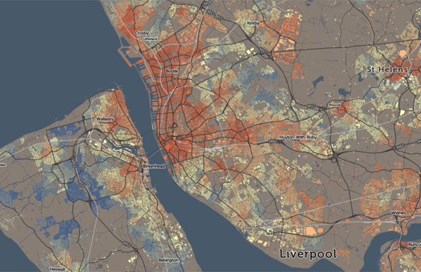
The Index of ‘Access to Healthy Assets and Hazards’ (AHAH) is a relative measure of accessibility to health promoting aspects of small areas (Lower-layer Super Output Areas (LSOAs) for England and Wales, and Data Zones for Scotland – hereby referred collectively as LSOAs) across Great Britain. The overall Index of Access to Healthy Assets and Hazards combines together indicators under three different domains of accessibility, detailed in the following sections:
- Retail environment
- Health services
- Physical environment
Retail Environment Domain
The domain focused on measuring the accessibility to retail services where individuals could purchase healthy or unhealthy foods and drink (and gambling which is indirectly related to health outcomes). We calculated the following measures of accessibility (the median distance (km) by car travel route of postcodes within a LSOA to nearest outlet):
- Fast food outlet
- Gambling outlets
- Pubs/bars/nightclubs
- Off licenses
- Tobacconists
Data on all retail businesses throughout Great Britain were provided by the Local Data Company (LDC). The data includes records for every operating retail business including a classification of retail type (e.g. fast food outlets, pubs, bars and nightclubs, bookmakers, casino clubs, off license, tobacconist) and the postcode of the store.
Health Services Domain
Geographic accessibility to health services has been demonstrated to be associated with utilization of services. We calculated accessibility (the median distance (km) by car travel route of postcodes within a LSOA to nearest service) to different health-related services including:
- GP surgeries
- A&E Hospitals
- Pharmacies
- Dentists
- Leisure Centers
Openly available data from NHS Digital and Information Services Division (ISD) in NHS Scotland were used for GP surgeries, A&E hospitals, pharmacies and dentists. Leisure centers were acquired from the LDC data.
Physical Environment Domain
We measure aspects of the physical environment which have demonstrated consistent associations to health and health-related behaviours:
- Level of Green Spaces (within a 900 meter buffer)
- Level of Nitrogen Dioxide (NO2)
- Level of Particulate Matter (PM10)
- Level of Sulphur Dioxide (SO2)
Open data from DEFRA on modelled air quality estimates was used for pollution variables. Green space locations were acquired from OpenStreetMap and the total green space areas within a 900 meter buffer of each postcode were calculated.
Methods
Accessibility measures were created using the Routino open source tool. Routino is an application for finding a route between two points using the OSM road network and takes into account restrictions on roads as well as tagged speed limits and barriers. In this study, we measured the network distance (travel time) between the centroid of each postcode in Great Britain and the coordinates of the nearest service (e.g. postcode centroid of GP practice).
Measured network distances for each indicator for postcodes were aggregated to the LSOA level providing average network distances for each indicator (as a measure of accessibility). All other indicators were also summarised for LSOAs. The indicators within each domain were standardised by ranking and transformed to the standard normal distribution. The direction of each variable was dictated by the literature (e.g. accessibility to fast food outlets were identified as health negating, whereas accessibility to GP practices was health promoting see Table 1). The maximum likelihood factor analysis technique was used to generate the weights to combine the indicators into the domain score (see Table 1 and Appendix I).
To calculate our overall index (and domain specific values), we followed the methodology of the 2015 IMD (Smith et al., 2015). For each domain, we ranked each domain R and any LSOA scaled to the range [0,1]. R=1/N for the most ‘health promoting’ LSOA and R=N/N for the least promoting, where N is the number of LSOAs in Great Britain. Exponential transformation of the ranked domain scores was then applied to LSOA values to reduce ‘cancellation effects’ (Smith et al., 2015). So, for example, high levels of accessibility in one domain are not completely cancelled out by low levels of accessibility in a different domain. The exponential transformation applied also puts more emphasis on the LSOAs at the end of the health demoting side of the distribution and so facilitates identification of the neighbourhoods with the worst health promoting aspects. The exponential transformed indicator score X is given by:
X = -23 ln (1 – R(1 – exp(-100 / 23)))
where ‘ln’ denotes natural logarithm and ‘exp’ the exponential transformation.
The main domains across our indicators: retail services, health services and the physical environment then were combined to form an overall ‘Index of Access to Healthy Assets and Hazards’ (AHAH).
References
Smith T., Noble M., Noble S., Wright G., McLennan D., Plunkett E. 2015. The English Indices of Deprivation 2015, Department for Communities and Local Government. Available at: https://www.gov.uk/government/publications/english-indices-of-deprivation-2015-technical-report [Accessed 10 Dec 2016]
Please cite as:
Daras K., Green M. A., Davies A., Singleton A., Barr B. 2017. Access to Healthy Assets and Hazards (AHAH): Short Technical Report. DOI: 10.13140/RG.2.2.11939.66083