

I have previously attemped to visit Morecambe: first in 2012 when I failed to get near; and then in 2017 when I got as far as Morecambe and moored, but did not go ashore.
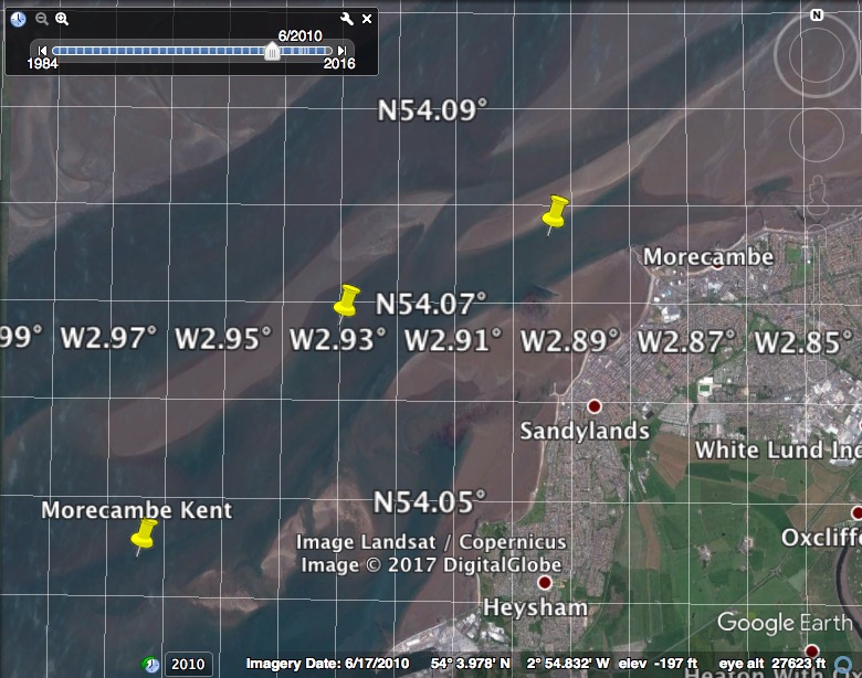
Discussion from my 2017 trip about the route to Morecambe: The chart of this area has regions surveyed at different dates with significant discontinuities where they join. The chart (as of 2017) of the Kent Channel (between Clark Wharf and Clark Wharf Spit) is based on a 1978 survey. North of 54° 03', the chart is based on even older input. I used Google Earth (with option to vary date of view) to show the channel into Morecambe (Kent channel which initially runs SW-NE) and set up some waypoints as shown.
From the route of my successful trip, I planned to approach in good weather and then have the option to go ashore.
Tuesday 26 June: leave Liverpool Marina 13:08 (Liv HW 10.54 8.5m; LW 17:36 2.0m; HW 23:12 8.7m) at the very end of the lock opening period. Calm and sunny with N 2-3 wind.
There were quite a few vessels in the Mersey:
Cruise ship Nautica being refuelled by Mersey Endurance; Seatruck
Pace (Liverpool-Dublin).
Wreck of PEGU with Formby Head behind; Blackpool.


Out via the shipping channel until ALPHA buoy when I took my shortcut going north at 12:37. Head past Lennox Rig with views of Blackpool. Current somewhat adverse after heading north. Getting even calmer later.
By 6:35 I reached the Lune Deep and headed in to Morecambe. Following my previous waypoints and track and looking at the sea surface for clues, I arrived at Morecambe at 8:25 (HW Morecambe - 3 hours). My keel was almost aground several times - but this corresponded to a deeper seabed than I had found previously. So far so good.
Heysham (port and nuclear power station);

At Morecambe, there were two vessels moored afloat in the moorings just east of the Stone Pier and there was one largish mooring buoy unoccupied. This buoy had no pick up buoy or top-ring and the current was running through the moorings at 2-3 knots. I made many attempts to tie onto the buoy - but, being single-handed, I could not get a line attached to it.
Morecambe: Stone Pier; Midland Hotel.


Options were to anchor - but in an area that has moorings, an anchor can get snagged in old chains - or wait for more depth and move to the moorings further east.
I decided, instead, to anchor off Half Moon Bay. This is further west, just before Heysham Port, and has deep enough water that it is accessible even at LW. Unfortunately from Morecambe the shortest route involves crossing a shallow area - but on a making tide approaching HW that was feasible. It is also feasible to anchor in the bay north of Throbshaw Point which has more shelter but dries.
At 9:10 (HW Morecambe - 2:15) I left Morecambe and headed for Half Moon Bay arriving at 9:40 with least depth 1.4m under my keel on my route. There is a green buoy marking a pipeline off Throbshaw Point and I anchored just southwest of that in 8.0m under my keel at 54 2.973N 2 54.808W. There was quite a strong current to the NE and my anchor dug in well. Tides in Heysham Lake (I was anchored at the extreme northeastern end of it) are listed as running at 3-5 knots maximum at springs with direction NE HW-5 to HW+1 and SW otherwise.
The headland (Throbshaw Point) at the north side of Half Moon Bay
has a rocky cliff (unusual in NW England) and a small church (St. Peters)
on it. There are also open stone graves and a ruined chapel dedicated
to St. Patrick built around the 8th century. These historic
buildings are in marked contrast to the nearby Heysham Port
Facilities and Nuclear Power Station.
In Half Moon Bay, somewhat south of my position is the (charted at
54 2.47N 2 54.94W and drying) remains of the wreck of the Sailing Vessel
Vanadis lost in 1903. See further info
.
Half Moon Bay (with full moon); Lake District Mountains at sunset.
My track and depths to Morecambe (at top right) (reduced using
Heysham tide-gauge to CD) with distances in metres (from this trip and
previous) and waypoints:
From the tracks of this trip, I revised my waypoints slightly to:
Note these waypoints do not represent the best or deepest route -
they are just what I used on one trip.
Wednesday 27 June. Liverpool LW 06:00 2.0m; HW 11:34 8.6m.
Since I had some boat problems (24 volt to 12 volt dropper serving
autopilot had failed - so hand steering required which is tedious when
single-handed), I decided to head back to Liverpool in time to make the
midday lock opening - then do repairs there. To get tidal assistance, I
set off at 4:25 (1:35 hours before local LW). The current was quite
gentle and the anchor came up easily. It was already light enough to see
and sunrise was soon afterwards. Another sunny and fairly calm day.
I passed Heysham at 4:35; Fleetwood at 5:18; Blackpool at 6:40;
Ribble Gut Buoy at 7:48; Lennox Rig at 8:24; and joined the Liverpool
Shipping Channel at buoy Alpha at 9:13. Current was mostly favourable
except for a period off the Ribble entrance. I locked into Liverpool
Marina at 10:28.
Stena Hibernia (Belfast-Heysham) entering Heysham; sunrise over Heysham.
Buoys: Yellow off Blackpool (west of South Pier); Ribble Gut (Ribble
Fairway buoy - "Rib Gut" which sounds painful).
Black Watch at Liverpool
Trip mainly at my displacement speed of 7 knots through the water.
Total distance 97nm.
A record of the depth and track of my voyage is available from
teamSurv
Clicking on an image should give a higher resolution picture. If
even higher resolution versions of the above images are wanted, please
contact me. All information given in good faith, but please do not rely
on it. Back to index here


