PS Lyra lost 1861; PS Maiden City stranded 1855
Jump to Maiden City 1855
Iron paddle steamer Lyra, built 1848 by Robert Napier, Govan
379 nrt, 218.7 ft x 25.5 ft x 12.9 ft
Engines by Robert Napier, 1 cyl, 275 nhp
For sale 1854
More history.
Owned City of Londonderry Co. from 1858
Voyage Belfast to Morecambe with 7 passengers and general cargo
Captain William Inch and 26 crew
Ran aground on Oyster Patches (part of Shell Wharf on S side of Lune Deep entry) 13 Feb 1861
Position (from pilot's bearings) 53°55.52N, 3°7.71W
Position of a candidate charted wreck 53°55.090N, 3°6.755W
Crew, passengers, cattle saved by PS Prince of Wales.
Slipped into deeper water and broke up.
Reports (mostly from Lancaster Guardian and Lancaster Gazette of Feb. and Mar.
1861):
WRECK OF THE LYRA:
The paddle steamer Lyra,
plying between Morecambe and Belfast the last month, struck on
what is believed to be a sunken wreck, near Shell Wharf, on Wednesday morning.
The master, finding the water gaining on them, ran her as far on shore as possible,
and asked a boat, the Prince of Wales steamer, for assistance. The latter
immediately went, and succeeded in getting off all the cattle and pigs,
except two, along
with all passengers, and landed them at Fleetwood. The vessel afterwards went
down and it is at present lying in twenty feet of water at low tide; provided the
weather keeps moderate, divers will be employed to get out the cargo, but should
it blow from westward it is doubtful but that she will become a total wreck.
SALVAGE OF THE WRECK OF THE LYRA. A fortnight ago, we announced that this fine
steamer of the
Morecambe and Belfast line, was wrecked on the Shell Wharf, near Fleetwood,
during the storm of the 13th Feb. She sank in deep water, and since that time
efforts have been made by divers from Donaghadee and Liverpool to recover
portions of the cargo. On Monday week, they succeeded in bringing two crates
of pigs, a few barrels of bacon, potatoes, and some sacks of oats. On Thursday
week, the wind blew from the south west, and seems to have materially affected
the condition of the vessel. The divers were able to reach the wreck on
Saturday, when they found that the after part was completely washed away; the
engines were standing, but the boilers had been washed off 30 yards on the
starboard side. On making their way to the fore hatch, they discovered the
front side of the ship entirely broken up, the iron plates of the sides
laid on the cargo, and the starboard side completely swept away. The only
remaining cargo, which they could meet with, was 18 bales of flax, which of
course was spoiled.
It was reported that much of the cargo had been washed
up at Walney, Piel and Sunderland. We believe that four bales of bacon
have been picked up at the latter place, and two barrels and one box of lard at
Piel.
The Lyra had on board a large quantity of flax consigned to Messrs. Waithman,
and 70 sacks of oats for Mr. Jas. Lewtas, but, in both cases, an insurance had
been effected on the goods. The vessel was insured for its full amount, and it
was valued at about £8000. The boat was only purchased in May last, and was
considered a very serviceable one for the station. The value of the cargo was
estimated at about £4000, and about half that amount was covered by insurance.
Yesterday [Friday 1 March], the boilers and other portions of the
recovered wreck were submitted to auction at Fleetwood.
A summary of the Board of Trade Inquiry held on Thursday and Friday (6 and
7 March 1861):
Report of inquiry: That the Lyra, a paddle steamer, 350 tons register,
sailed
from Belfast to Morecambe, on the evening of the 12th of February, laden with
a valuable general cargo. On the following morning, at half-past seven, Walney
light bore ENE at a distance of two and a half miles (as the mate states) but
the master computes the distance at five miles. From this position, a course
was steered SE by S, till an object was seen on the south shore near
Fleetwood. The weather was somewhat hazy, and it was difficult to define
distant landmarks with precision. The object discovered was taken to be the
Screw Pile light [Wyre light] by the master, and it was first seen on the port
bow. Nevertheless the master states he did not alter his course for fifteen
minutes, although
the bearing of it at the time would have shown that it could not be the Wyre
light. The vessel proceeded at full speed, at a rate of 9.5 knots per hour; and on
approaching nearer, he
discovered his error, the object being the Rossall land mark.
He then gave direction to haul up more to the eastward, in the hope of getting
into his proper course in Lune Deep, over which he had previously passed.
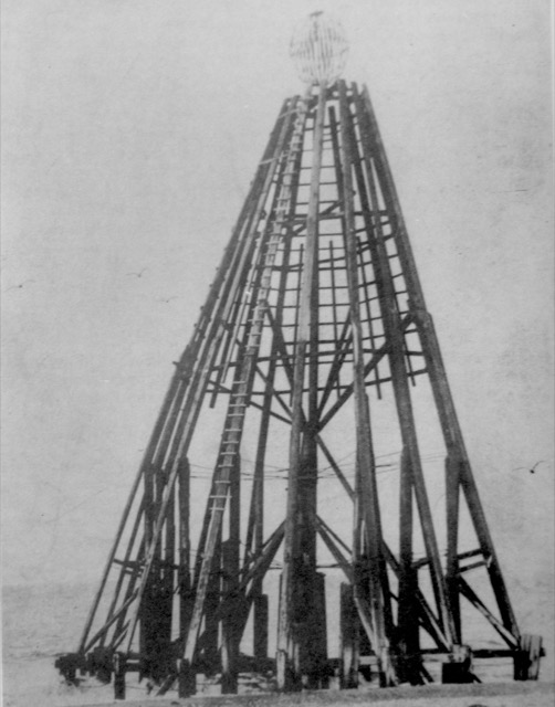
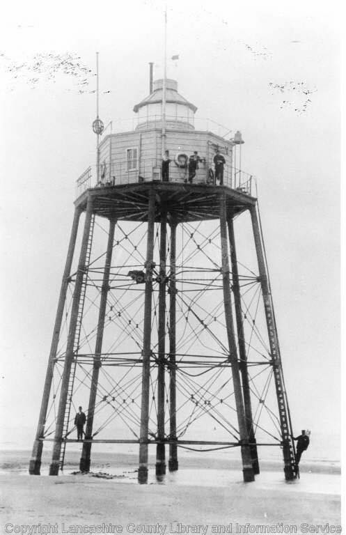
The captain's confusion: Images of Rossall Point Landmark (was at 53°
55.23N, 3°3.03W, now collapsed) and Wyre Light (part collapsed 2017)
The ship struck, quickly filled, the fires were put out, and the ship
eventually sunk not far from where she first struck. Providentially no lives
were lost, assistance having been rendered by the Prince of Wales steamer,
then moored at the Wyre lighthouse. When a vessel is proceeding to Fleetwood
or Morecambe across the bay from Walney, the real course is to get soundings
in Lune Deep, particularly if the weather be so hazy as to obscure distant
marks, a precaution which in this instance was entirely neglected by the
master. Nor does it seem, though the weather was hazy and the object first but
indistinct, that the engine was slowed, or any precaution taken on entering an
intricate channel. On the contrary, when the master discovered his mistake, he
continued full speed in the hope of regaining the deep channel, a proceeding
which, in all probability, precipitated the destruction of the ship, for it
would appear that at that time, though in shallow water, the vessel had not
actually struck.
After considering the evidence, we are of the opinion that the Lyra was
lost by the default of William Inch, her master. And in compliance with the
438th section of the Merchant Shipping Act, 1854, we forward his certificate
of competency for a home trade passenger ship to the Board of Trade, to be
dealt with as my Lords may think fit.
In the course of this inquiry, it was elicited that the Walney light and
Rossall beacon are under the control and management of the Commissioners of
St. George's Quay, Lancaster, who receive a toll of 3d per ton per annum from
every vessel entering the estuary, and that formerly a buoy was placed on the
SW prong of the Oyster bank, which has long since ceased to exist. We beg
particularly to call attention to the fact that, as from the evidence of John
Hesketh, a pilot of this port, it appears numerous small vessels have been
lost near the spot where the Lyra grounded. A buoy placed in the position
indicated would, in the opinion of this witness, be of great service when the
landmarks are not easily distinguishable. In this opinion we beg to express
our concurrence.
Several excellent testimonials were handed in giving Mr. Inch a good character for
sobriety, good conduct, and careful attention to his duties, which will no doubt
weigh with your lordships in your decision.
A fuller report is contained here.
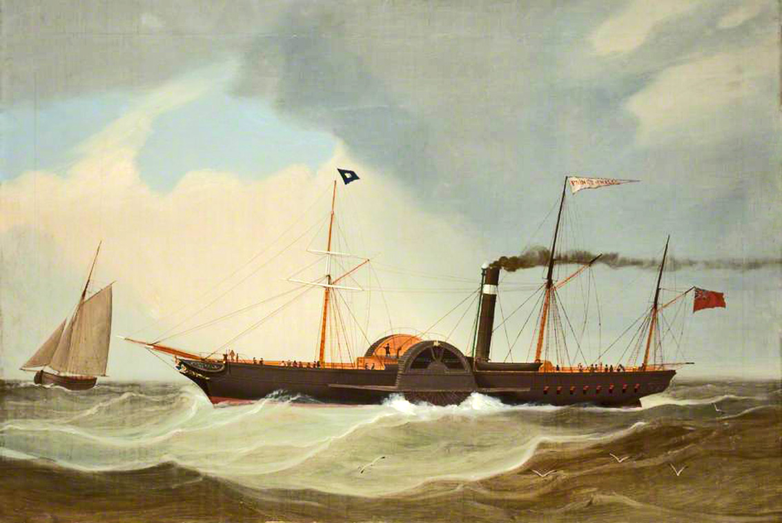
Information: The rescuing vessel, PS Prince of Wales, was built 1842 by Tod
MacGregor, [313 nrt, 500grt, ON 17230] was owned by the Lancashire and Yorkshire Railway Company and
provided a Fleetwood-Belfast service. She was anchored, with steam up,
near the Wyre light, waiting for the tide to rise before heading in to Fleetwood.
She was alerted to the demise of the Lyra by Fleetwood Pilot John Hesketh who was
a lookout on the Wyre light.
Image of Prince of Wales:
A buoy "Shell Wharf" now marks this south side of the entry to the Lune Deep.
Location of wreck: bearings taken from the wreck by the Fleetwood Pilot are
reported by the newspapers: Wyre [or Pile] Light (E by N 1/2 N); Rossall Mark
(E) and Danger Patch buoy (NE by N 1/2 N). These bearings are 73, 90, 28
degrees in modern notation. If they were magnetic bearings, correction for the
magnetic variation, which was about 24° at that date, would yield 49, 66,
04 degrees which seems rather too far from the Lune Deep so unlikely. The Rossall
Mark and Wyre Light were in positions now known accurately (see above for
Rossall Mark), whereas the Danger Patch buoy may have been moved as the
channel shifted. The pilot also states that the wreck was at 2.75nm from the
Rossall Mark and 0.5 to 0.75nm from the Lune Deep.
The Lyra was described by the captain as drawing 9ft 1in aft and
8ft 7in forward. HW was around 12:42, so she struck not long after LW, with a
spring tide: so typically a tidal depth of 2-3m. She took on water soon after
striking and the engineer described the sound as a "tear". So she is likely to
have hit a boulder or rock, rather than sand or shingle.
Since Rossall Mark from the wreck was at approximately 2.75nm at
90° which corresponds to the region west of the end of the charted pipeline
over Shell Wharf: an area called North West Boulders or Rossall Patches. This
position (approximately 53°55.52N, 3°7.71W) is now charted as having a
patch that has depth 1.9m; it is 2.81nm at 96° to the Rossall Mark, 3.9nm
at 65° to the Wyre Light, 33° to the Danger Patch Buoy [2019 position]
and about 0.27nm from the Lune Deep [2019 position]. There is (now) a depth of
5m not far away, so the vessel would end up in deeper water (20ft at LW
quoted).
The only charted wrecks near this position are more recent than
1861 and there are no charted obstructions near this location. However, one of
the charted wrecks, 0.7nm away, is also listed as "SS Lyra". This is the wreck
that was reported to the Hydrographic Office in 1922 as "SS Lyra" at
53°55.090N, 3°6.755W at depth 0.3m. This wreck site was marked by a
wreck buoy marked "Lyra" from 1924 until 1971. The Hydrographic Office lists
that this may be the wreck of the SS Lyra (b 1881 Sunderland, ex-Kant, Finnish
owned). However, there is no record of any SS Lyra sinking near Fleetwood in
1922, or shortly before, and the SS Lyra, which is named as a candidate by the
HO, actually continued trading long after 1922. So, a likely scenario is that
local knowledge of the location and remains of the wreck of the SS Lyra in
1861 continued thereafter, but was only communicated to the Hydrographic
Office 60 years later, in 1922. Another scenario is that wreckage was detected
around 1922 and was assumed from its location to be the Lyra (wrecked 1861)
but was actually from some other source.
Note that this charted wreck position is 85° at 2.2nm to the Rossall
Landmark, 54° at
3.6nm to the Wyre light and 15° to the Danger Patch Buoy. This is thus
close to the area described by the pilot's bearings. Although, it is now 0.9nm
from the Lune Deep - which is a little more than his estimate, and it is shallower
than the reported 20ft at low water.
[from Northern Daily Times - Friday 18 August 1854]:
The powerful and well known paddle-wheel steamer, LYRA, 397 tons
register, 591 tons builder's measureent, built at Glasgow of iron in
1849 by Robert Napier Esq, who also manufactured the engines, which are
about 300 horse-power, she has one cylinder 84 inches diameter, 7 feet
stroke, draws only 10.5 feet water when loaded, carries largely, and has
first-rate accommodation for a great number of cabin and steerage
passengers, now plying between this port [Liverpool] and Belfast.
Also, the superior paddle-wheel Steamer, MAIDEN CITY, 342 tons register,
650 tons builders' measurement. Breadth 26 feet, depth 18 feet, height
between decks 8 feet, built of wood at Londonderry, in 1842, under
particular inspection, of well-seasoned materials. She is propelled by
two superior side-lever engines of 280 horse power; cylinders each 62
inches diameter; length of stroke 6 feet; she stows a large cargo, and,
from her great roominess on deck, is well adapted for the conveyance of
troops or cattle; has excellent accommodation for a large number of deck
and cabin passengers. In 1851 she had a general overhaul, when she had
new boilers, new deck and paddle-boxes, re-treenailed throughout, and
yellow metalled; she shifts without ballast; draft of water 13.5 feet,
with 300 tons; speed 10.5 knots; is now in first rate working order,
plying between the ports of Fleetwood and Londonderry, and may be
inspected at the former Port every Saturday. For inventories and
further particulars apply to CUNARD, MUNN & CO., Brokers.
[advert, Dec 1854, as above but said to be plying Liverpool -
Londonderry]
Wooden paddle steamer Maiden City, built Croppin,
Londonderry, 1841, 630grt, 342nrt, 182 x 27.3 ft, engines 320 hp, ON
1360. Owned North West of Ireland Steamship Co., Londonderry,
registered Londonderry. Offered for sale 1854. Stranded near Maughold
Head, Isle of Man,
6th June 1855. Refloated and chartered for towage to Crimea.
Broken up 1860.
More
history.
For sale 1854.
[from Londonderry Standard - Thursday 07 June 1855]:
THREE COMMUNICATIONS WEEKLY between DERRY AND LIVERPOOL, PER THE
LONDONDERRY STEAMBOAT COMPANY'S Steamships, LYRA and MAIDEN CITY, and at
Through Fares by Railway to ENNISKILLEN, thence to SLIGO, BALLYSHANNON,
and the NORTH-WEST of IRELAND generally; also, by Railway to COLERAINE. ...
[from Londonderry Standard - Thursday 14 June 1855]:
LOSS OF THE LONDONDERRY STEAMBOAT COMPANY'S VESSEL, MAIDEN CITY. We
regret to have to announce the loss of the above steamer, the
property of the Londonderry Steamboat Company, and for a lengthened
period trading between this port and Liverpool. We extract from the
Liverpool Chronicle the full particulars of the melancholy disaster.
Our contemporary says:
She started from this port at four P.M., on the
6th instant, for Londonderry, under the command of Captain Chas.
M'Laughlin, with three cabin and thirty steerage passengers, and crew
of eighteen men, on board. She had about 250 bales of goods as cargo,
a large proportion of which consisted of guano and breadstuffs.
Shortly after she left port, a dense fog set in, and about half-past
eleven, pm, she struck the rocks under Maughold Head, within a short
distance of Ramsey, Isle of Man. She ran steam [sic stem?] on, in a
creek, the rocks rising on each side, on which the passengers
clambered immediately on her striking. The inhabitants of the village
of Kirkmahol [sic, Kirk Maughold?], in the immediate vicinity of the spot where she struck,
attracted by the sound of the steam being blown off, at once hastened
with lanterns to render any assistance in their power. In the meantime
Captain McLaughlin despatched the mate and engineers to Ramsey, in
order to send a boat to await the arrival of the steam-ship Lyra,
Captain Crompton, of the same line, which was expected to pass Ramsey
early next morning. After remaining a considerable time afloat, the
Lyra came in sight, and about seven, am, on the 7th, the boat was
taken on board. Upon learning the unfortunate occurrence. Captain
Crompton immediately proceeded to the wreck, when he found the vessel
full of water, but perfectly upright. He immediately lowered two boats
and with the assistance of those belonging to the Maiden City, he
succeeded in transferring the steerage passengers and their luggage on
board the Lyra without a single accident. After lying by the wreck for
the space of two hours, the Lyra proceeded to Liverpool. The Maiden
City, at last accounts, lay in a very dangerous position, being quite
under water at high tide. Captain M'Laughlin and crew remain in the
neighbourhood of the vessel to take any steps towards the recovery of
the cargo and saving of the steamer which may deemed advisable. The
rescued passengers speak in the highest terms of Captain Crompton,
after taking them on board the Lyra. Captain M'Laughlin's conduct, at
the time of the unfortunate disaster, is also highly spoken of by
those who were on board, and a general feeling of regret is expressed
on his account at the untoward event, he having succeeded to command
about twelve months since, having occupied the position of chief mate
(and often that of commander, in the illness of the captain) since
1841, where his courteous manner, as well as his known experience as
seaman, having made 1,000 passages across the channel, secured for him
the confidence and respect of a large class of commercial friends.
From inquiries which have made, we learn that every exertion is
being used to save the cargo; but it is be feared that a considerable
portion of the goods on board the vessel will be seriously damaged, as
her deck is covered at high water. In the meantime, the requirements
of the trade will not suffer, another steamer having been placed on
the line in lieu of the Maiden City.
[from Londonderry Standard - Thursday 21 June 1855]:
WRECK OF THE MAIDEN CITY, FOR THE BENEFIT OF WHOM IT MAY CONCERN, great
sale of drapery goods, PARTIALLY DAMAGED BY SEA WATER. The SUBSCRIBER
will commence This Day to Sell, for the Benefit of whom it may Concern,
large quantity of SILK MERCERY, DRAPERY, AND HABERDASHERY GOODS, saved
from the wreck of the steamer.
[from Banner of Ulster - Thursday 05 July 1855]:
The steamer Maiden City, which was ashore at Port Mooare [sic, Mooar],
has been got off, and towed down to Ramsey, to undergo temporary
repairs, in order to proceed to some port across the Channel.
[from Shipping and Mercantile Gazette - Thursday 05 July 1855]:
RAMSEY, I.M. - The steamer, Maiden City, which was towed in
here after having been ashore, having been temporarily repaired,
proceeded yesterday, 24 inst., in charge of Captain Coppin to Ardrossan,
to undergo repairs; her engines worked well.
[from Londonderry Standard - Thursday 29 November 1855]:
The result of the Maiden City being got off - under very peculiar
circumstances, to which he would not now allude - after having been
wrecked, was at first regarded as a calamity, but had turned out very much
to the advantage of the Company. That vessel was now profitably
chartered for six months certain, and twelve months optional, for a sum
which would not only repay the money at which she was valued in their
last account, but also the amount which they had expended in repairs.