

Puffin Island (Welsh: Ynys Seriol) is at the SE corner of Anglesey. It is uninhabited and is privately owned (Baron Hill Estate) and permission is required to land. It is an SSSI (Site of Special Scientific Interest).
See: some info about access. A research group (SCAN) have been studying the wildlife there.
Boats regularly tour Puffin Island, starting from Beaumaris Pier. As well as the many seabirds, seals haul out on the rocks at the NE end. Do not disturb the birds or seals.
The building (with chimney) visible is the remains of a semaphore relay station built in 1827 and improved in 1841. It was used as a Biological Research Station by Liverpool University for a period from 1885. There are also remains of a much older monastery. The cliffs are home to many seabirds. Despite its name, there are few puffins (around 50 pairs during the April-July breeding season). The most prominent seabird is the Great Cormorant.
Boat navigation: I often navigate close to Puffin Island, anchor overnight, dive on the north-west side and take divers there. This is a summary of what I know. Local Beaumaris boat skippers will be even more knowledgeable.
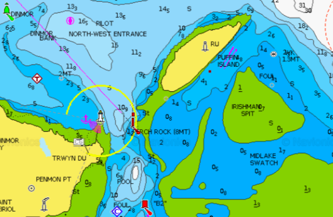
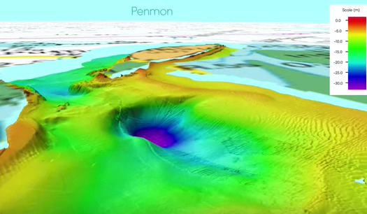
Puffin Island (mini chart here) is fairly steep to, except for a sand spit that runs from the southern end. This dries at spring LW, but can be negotiated by shallow draught vessels using the route around the spit. The spit is illustrated in the depth profile obtained by Bangor University: here, snaking along edge of the main channel into the Menai Straits via Trwyn Du.
I surveyed this spit a few years ago and established waypoints which I have used successfully ever since. The HO chart shows this spit but the data are based on a survey from 1959-62. My waypoints are not far from the route shown on the chart but I prefer to use them:
| Waypoint | Lat. N | Long. W |
| PUF1 | 53 18.740 | 4 1.950 |
| PUF2 | 53 18.510 | 4 1.840 |
| PUF3 | 53 18.490 | 4 1.890 |
Do not rely on these waypoints - check yourself at mid-tide or above. The sand banks can move significantly in as little as a few weeks.
Waypoints shown on chart; depth from my survey showing spit
| |
|
I regularly anchor overnight SE of Puffin Island - in a few metres at LW. This spot is sheltered from most wind directions but it does have quite a strong tidal current. The birds will wake you up in the morning quite early too, with their noise.
Tidal currents: in Puffin Sound (between Trwyn Du and Puffin Island)
the current turns at HW(Liv)-75 and at LW(Liv)-30 approximately.
The current on the ebb is stronger along the NW side of the
island; and on the flood along the SE side; however, the flood along the
SE side does not start until HW(Liv) - 4 hours approximately.
Some images: Cormorants; the ruined buildings, seals lounging on the rocks.
 |
 |
 |